Ficheiro:Australia-New Guinea (orthographic projection).svg

Tamaño desta vista previa en PNG do ficheiro en formato SVG: 541 × 541 píxeles. Outras resolucións: 240 × 240 píxeles | 480 × 480 píxeles | 768 × 768 píxeles | 1.024 × 1.024 píxeles | 2.048 × 2.048 píxeles.
Ficheiro orixinal (ficheiro SVG; resolución de 541 × 541 píxeles; tamaño do ficheiro: 293 kB)
| Este ficheiro procede de Wikimedia Commons. A continuación móstrase a información da súa páxina de descrición. Commons é un repositorio libre de ficheiros multimedia. Pode contribuír alí cargando as súas imaxes. |
| Descrición |
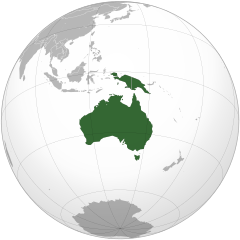
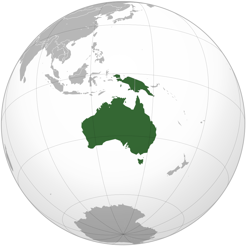
English: Map highlighting the continent of Australia-New Guinea. Includes Australia (including Tasmania) and New Guinea (including eastern portion of Indonesia (Aru Islands)) and mainland provinces of Papua New Guinea) south/east of Lydekker Line (delimiting continental shelf) |
| Data | (UTC) |
| Orixe | |
| Autoría |
|
| Outras versións |
.svg) |
.svg)
.svg)
.svg)
.svg)
.svg)
.svg)
.svg)
.svg)
.svg)
.svg)
.svg)
.svg)
.svg)
.svg)
.svg)
.svg)
.svg)
.svg)
.svg)
.svg)
.svg)
.svg)
.svg)
.svg)
.svg)
.svg)
.svg)
.svg)
.svg)
.svg)
.svg)
.svg)
.svg)
.svg)
.svg)
.svg)
.svg)
.svg)
.svg)
.svg)
.svg)
.svg)
.svg)
.svg)
.svg)
.svg)
.svg)
.svg)
.svg)
.svg)
.svg)
.svg)
.svg)
.svg)
.svg)
.svg)
.svg)
.svg)
.svg)
.svg)
.svg)
.svg)
.svg)
.svg)
.svg)
.svg)
.svg)
.svg)
.svg)
.svg)
.svg)
.svg)
.svg)

.svg)

.svg)

.svg)
.svg)
.svg)
.svg)
.svg)
.svg)
.svg)


.svg)
.svg)
.svg)
.svg)
.svg)
.svg)
.svg)

.svg)
.svg)
.svg)
.svg)
.svg)
.svg)
.svg)
.svg)
.svg)

.svg)
.svg)
.svg)
.svg)
.svg)
.svg)
.svg)
_without_national_boundaries.svg)
.svg)
.svg)
.svg)
.svg)
.svg)
.svg)

.svg)
.svg)
.png)
.svg)
.svg)
.svg)
.svg)

.svg)
.svg)
.svg)
.svg)
.svg)
.svg)
.svg)
.svg)
.svg)
.svg)
.svg)

.svg)
.svg)
.svg)
.svg)
.svg)
.svg)
.svg)
.svg)
.svg)

.svg)
.svg)

.svg)
.svg)
.svg)
.svg)
.svg)
.svg)
.svg)
.svg)
.svg)
.svg)
.svg)
.svg)
.svg)
.svg)
.svg)
.svg)
.svg)
.svg)
.svg)
.svg)
.svg)
.svg)
.svg)
.svg)
.svg)
.svg)
.svg)
_-_Crimea_disputed.svg)
.svg)
.svg)
.svg)
.svg)
.svg)
.svg)
.svg)
.svg)
.svg)
.svg)
.svg)
_political.svg)
.svg)
.svg)
.svg)
.svg)
_-_Crimea_disputed_-_no_borders.svg)
.svg)
.svg)
.svg)
.svg)
.svg)
.svg)
.svg)
.svg)
.svg)
.svg)
.svg)

.svg)
.svg)
.svg)

.png)
.svg)
.svg)
.svg)
.svg)
.svg)
.svg)
.svg)
.svg)
.svg)
.svg)
.svg)
.svg)
.svg)
.svg)
.svg)
.svg)
.svg)
.svg)
.svg)
.svg)
.svg)
.svg)
.svg)
.svg)
.svg)
.svg)
.svg)
.svg)
.svg)
.svg)
.svg)
.svg)
.svg)
.svg)
.png)
.svg)
.svg)
.svg)
_(orthographic_projection).png)
.svg)
Map includes Australia (including Tasmania and Torres Strait Islands) and New Guinea (including eastern portion of Indonesia (Aru Islands)) and mainland provinces of Papua New Guinea) south/east of Lydekker Line (delimiting continental shelf)
Eu, como posuidor dos dereitos de autor desta obra, pola presente publícoa baixo as seguintes licenzas:
| Este ficheiro está licenciado baixo a licenza Creative Commons recoñecemento compartir igual 3.0 sen adaptar. | ||
| ||
| A etiqueta desta licenza engadiuse a este ficheiro como parte da actualización da licenza GFDL. |

|
Autorízase a copia, distribución e/ou modificación deste documento baixo os termos da licenza de documentación libre GNU, versión 1.2 ou calquera outra que posteriormente publique a Free Software Foundation; sen seccións invariables, textos de portada, nin textos de contraportada. Inclúese unha copia da devandita licenza na sección titulada GNU Free Documentation License. |
Pode seleccionar a licenza que desexe.
The map has been created with the Generic Mapping Tools: https://www.generic-mapping-tools.org/ using one or more of these public-domain datasets for the relief:
|
|
|
Autorízase a copia, distribución e/ou modificación deste documento baixo os termos da licenza de documentación libre GNU, versión 1.2 ou calquera outra que posteriormente publique a Free Software Foundation; sen seccións invariables, textos de portada, nin textos de contraportada. Inclúese unha copia da devandita licenza na sección titulada GNU Free Documentation License. |
Rexistro de cargas orixinal
This image is a derivative work of the following images:
- File:Australia_(orthographic_projection).svg licensed with Cc-by-sa-3.0-migrated, GFDL-GMT
- 2009-08-12T00:17:33Z Addicted04 541x541 (292902 Bytes) Meridianos
- 2008-11-09T13:20:33Z Ssolbergj 541x541 (292870 Bytes) {{Information |Description={{en|1=Australia}} |Source=Own work, {{Inkscape}}[http://www.aquarius.geomar.de/omc/make_map.html Aquarius.geomar.de]{{GFDL-GMT}} |Author=[[User:Ssolbergj|Ssolbergj]] |Date=9 November 2008 |Permissi
Carregada com derivativeFX
Historial do ficheiro
Prema nunha data/hora para ver o ficheiro tal e como estaba nese momento.
| Data/Hora | Miniatura | Dimensións | Usuario | Comentario | |
|---|---|---|---|---|---|
| actual | 17 de febreiro de 2016 ás 15:15 | | 541 × 541 (293 kB) | Maphobbyist | Reverted to version as of 14:25, 12 December 2009 (UTC) |
| 19 de novembro de 2012 ás 03:28 |  | 541 × 541 (281 kB) | Kwamikagami | add Outer Banda Arc | |
| 12 de decembro de 2009 ás 14:25 |  | 541 × 541 (293 kB) | Avenue | {{Information |Description={{en|1=Continent of Australia-New Guinea}} |Source=*File:Australia_(orthographic_projection).svg |Date=2009-12-12 14:19 (UTC) |Author=*File:Australia_(orthographic_projection).svg: [[User: |
.svg)
Uso do ficheiro
As seguintes 29 páxinas usan este ficheiro:
- América
- América do Norte
- América do Sur
- Antártida
- Armórica (continente)
- Asia
- Atlántida
- Avalonia
- Báltica
- Casaquistania
- Continente
- Eurafrasia
- Eurasia
- Europa
- Genealogy
- Gondwana
- Laurasia
- Laurentia
- Laurusia
- Lemuria (continente)
- Oceanía
- Pannotia
- Panxea
- Rodinia
- Sahul
- Siberia (continente)
- Subcontinente indio
- África
- Modelo:Continentes
Uso global do ficheiro
Os seguintes wikis empregan esta imaxe:
- Uso en ab.wikipedia.org
- Uso en af.wikipedia.org
- Uso en ar.wikipedia.org
- آسيا
- أوروبا
- قارة
- أستراليا
- القارة القطبية الجنوبية
- أوقيانوسيا
- أمريكا الشمالية
- أمريكا الجنوبية
- بوابة:آسيا
- بوابة:أوروبا
- العالم الجديد
- أوراسيا
- أطلانطس
- الأمريكتان
- شبه القارة الهندية
- بانجيا
- تصنيف:تصنيفات حسب القارة
- غندوانا
- أفرو-أوراسيا
- أستراليا (قارة)
- تغير أسماء دول آسيا خلال القرن العشرين
- إفريقيا
- ليموريا (قارة)
- القارات في العصر الجوراسي
- قالب:قارات العالم
- أطلانتيكا
- قارة غارقة
- أركتيكا
- آسيامريكا
- بانجيا الأخرى
- أماسيا (قارة)
- لوراسيا
- بانوتيا
- نوفوبانجيا
Ollar o uso global deste ficheiro.
.svg)
.svg)