Ficheiro:WorldMapCosmasIndicopleustes.jpg
Ficheiro orixinal (1.539 × 1.208 píxeles; tamaño do ficheiro: 654 kB; tipo MIME: image/jpeg)
| Este ficheiro procede de Wikimedia Commons. A continuación móstrase a información da súa páxina de descrición. Commons é un repositorio libre de ficheiros multimedia. Pode contribuír alí cargando as súas imaxes. |
Resumo
| Descrición |
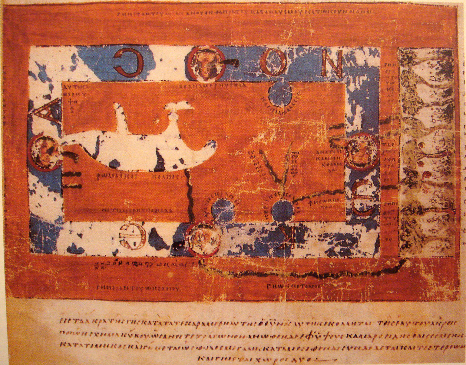
World Map by Cosmas Indicopleustes. The map is oriented with north to the top. It shows a rectangular landmass in the middle of the World Ocean ( ꙌΚΕΑΝΟϹ , Okeanos), reflecting what Cosmas thought was the "floor" of the tabernacle-shaped universe. The Roman Gulf (i.e., Mediterranean) is shown in the western half, with indentations for the unmarked Adriatic and Aegean/Black seas. Three further gulfs are shown: the Caspian to the northeast and the Arabian (i.e., Red Sea) and Persian gulfs to the south. Paradise is shown in the far east, beyond the Ocean. Four rivers run from it and cross under or through the Ocean to reach Asia and Africa. |
| Data | 6th century map. |
| Orixe | "Les Sciences au Moyen-Age", "Pour la Science" |
| Autoría | Cosmas Indicopleustes, 6th century |
| Outras versións |
|

Licenza
|
Esta é unha reproducción fotográfica fiel dunha obra de arte bidimensional no dominio público. A obra de arte en si mesma atópase no dominio público polo seguinte motivo:
A posición oficial da Fundación Wikimedia é que "as reproducións fieis de obras de arte bidimensionais no dominio público atópanse en si mesmas no dominio público". Esta reprodución fotográfica considérase polo tanto no dominio público. Noutras xurisdicións a reutilización deste contido pode estar rextrinxida; vexa Reutilización de fotografías PD-Art para máis información. {{PD-Art}} template without license parameter: please specify why the underlying work is public domain in both the source country and the United States
(Usage: {{PD-Art|1=|deathyear=''year of author's death''|country=''source country''}}, where parameter #1 can be PD-old-auto, PD-old-auto-expired, PD-old-auto-1996, PD-old-100 or similar. See Commons:Multi-license copyright tags for more information.) | ||||
| Anotacións | Esta imaxe ten anotacións: Olle as anotacións en Commons |
Historial do ficheiro
Prema nunha data/hora para ver o ficheiro tal e como estaba nese momento.
| Data/Hora | Miniatura | Dimensións | Usuario | Comentario | |
|---|---|---|---|---|---|
| actual | 16 de novembro de 2007 ás 18:33 | | 1.539 × 1.208 (654 kB) | World Imaging | {{Information |Description=World Map by Cosmas Indicopleustes |Source="Les Sciences au Moyen-Age", "Pour la Science" |Date=6th century map. |Author=Cosmas Indicopleustes, 6th century |Permission= |other_versions= }} |
Uso do ficheiro
A seguinte páxina usa este ficheiro:
Uso global do ficheiro
Os seguintes wikis empregan esta imaxe:
- Uso en ar.wikipedia.org
- Uso en ca.wikipedia.org
- Uso en ceb.wikipedia.org
- Uso en de.wikipedia.org
- Uso en el.wikipedia.org
- Uso en en.wikipedia.org
- Uso en eo.wikipedia.org
- Uso en es.wikipedia.org
- Uso en fa.wikipedia.org
- Uso en fa.wikibooks.org
- Uso en fi.wikipedia.org
- Uso en fr.wikipedia.org
- Uso en he.wikipedia.org
- Uso en hr.wikipedia.org
- Uso en id.wikipedia.org
- Uso en it.wikipedia.org
- Uso en it.wikiquote.org
- Uso en ja.wikipedia.org
- Uso en ka.wikipedia.org
- Uso en la.wikipedia.org
- Uso en nl.wikipedia.org
- Uso en pl.wikipedia.org
- Uso en pt.wikipedia.org
Ollar o uso global deste ficheiro.