Ficheiro:NPS gates-of-the-arctic-map.jpg

Tamaño desta vista previa: 707 × 600 píxeles. Outras resolucións: 283 × 240 píxeles | 566 × 480 píxeles | 905 × 768 píxeles | 1.207 × 1.024 píxeles | 2.414 × 2.048 píxeles | 2.996 × 2.542 píxeles.
Ficheiro orixinal (2.996 × 2.542 píxeles; tamaño do ficheiro: 1,45 MB; tipo MIME: image/jpeg)
| Este ficheiro procede de Wikimedia Commons. A continuación móstrase a información da súa páxina de descrición. Commons é un repositorio libre de ficheiros multimedia. Pode contribuír alí cargando as súas imaxes. |
Resumo
| Descrición |
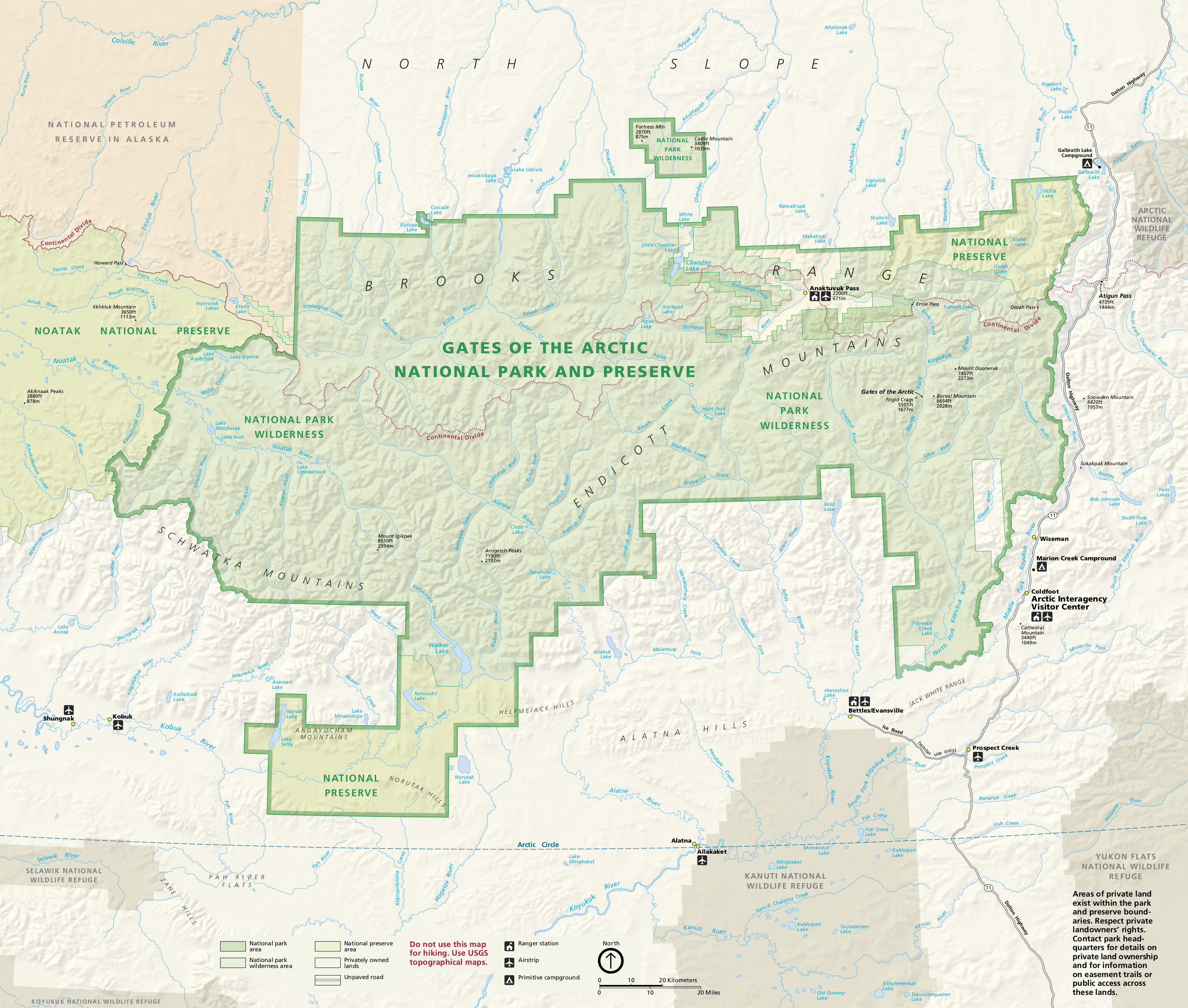
English: Gates of the Arctic map from the official brochure, showing the layout of the park and some of the surrounding Alaska region. |
| Data | |
| Orixe | U.S. National Park Service (http://npmaps.com/wp-content/uploads/gates-of-the-arctic-map.jpg) |
| Autoría | U.S. National Park Service, restoration/cleanup by Matt Holly |
| Outras versións |
 |
Licenza
| This image or media file contains material based on a work of a National Park Service employee, created as part of that person's official duties. As a work of the U.S. federal government, such work is in the public domain in the United States. See the NPS website and NPS copyright policy for more information. |
Historial do ficheiro
Prema nunha data/hora para ver o ficheiro tal e como estaba nese momento.
| Data/Hora | Miniatura | Dimensións | Usuario | Comentario | |
|---|---|---|---|---|---|
| actual | 16 de maio de 2017 ás 21:28 | | 2.996 × 2.542 (1,45 MB) | RKBot | =={{int:filedesc}}== {{Information |description= {{en|1=Gates of the Arctic map from the official brochure, showing the layout of the park and some of the surrounding Alaska region.}} |date= 2016-04-10 |source= U.S. National Park Service (http://npmaps... |
Uso do ficheiro
A seguinte páxina usa este ficheiro:
Uso global do ficheiro
Os seguintes wikis empregan esta imaxe:
- Uso en en.wikipedia.org