Ficheiro:L'île de la Réunion vue par le satellite Sentinel-2 (cropped).jpg

Ficheiro orixinal (5.000 × 4.232 píxeles; tamaño do ficheiro: 18,68 MB; tipo MIME: image/jpeg)
| Este ficheiro procede de Wikimedia Commons. A continuación móstrase a información da súa páxina de descrición. Commons é un repositorio libre de ficheiros multimedia. Pode contribuír alí cargando as súas imaxes. |
Resumo
| Descrición |
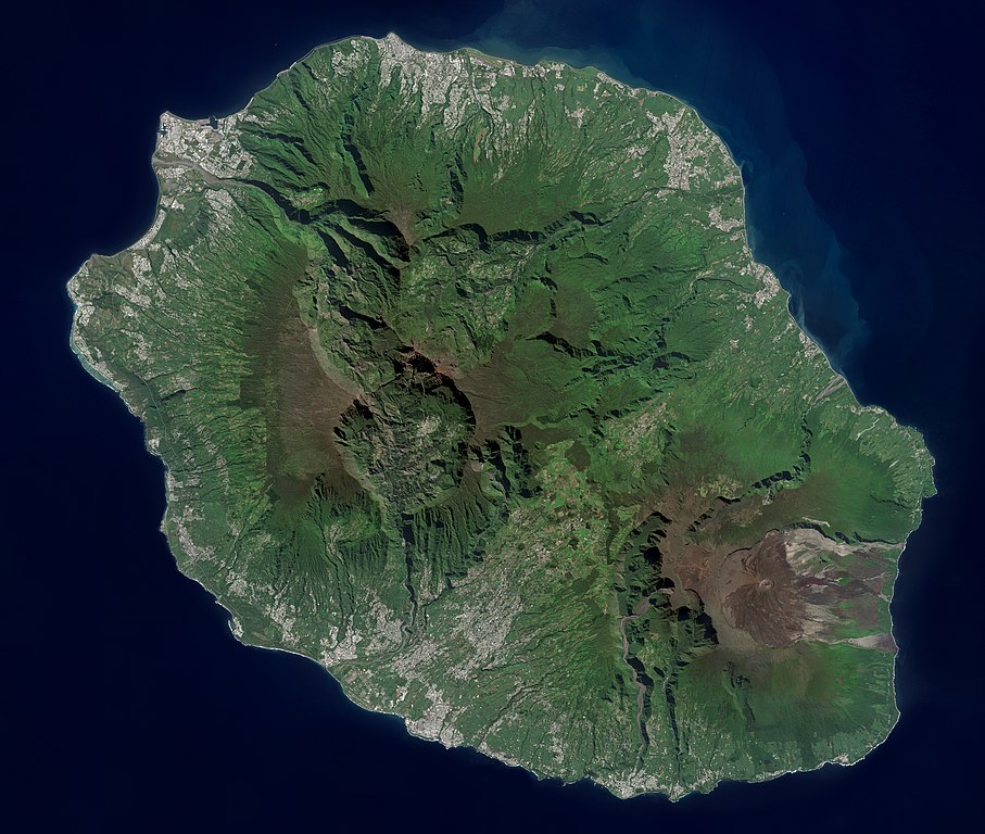
Français : L'île de la Réunion vue par le satellite Sentinel-2
English: Réunion island (Indian Ocean) photographed by Sentinel-2 satellite. |
| Data | |
| Orixe | https://phototheque.cnes.fr/cnes/media/68926 |
| Autoría | European Space Agency / CNES |
| Outras versións |

.jpg)
| Localización da cámara | | Esta e outras imaxes na súa localización en: OpenStreetMap |
|---|
.jpg¶ms=-21.134472_N_0055.247103_E_globe:Earth_type:camera__&language=gl)
Licenza

|
This image contains data from a satellite in the Copernicus Programme, such as Sentinel-1, Sentinel-2 or Sentinel-3. Attribution is required when using this image.
Recoñecemento: Contains modified Copernicus Sentinel data 2021
The use of Copernicus Sentinel Data is regulated under EU law (Commission Delegated Regulation (EU) No 1159/2013 and Regulation (EU) No 377/2014). Relevant excerpts:
Free access shall be given to GMES dedicated data [...] made available through GMES dissemination platforms [...].
Access to GMES dedicated data [...] shall be given for the purpose of the following use in so far as it is lawful:
GMES dedicated data [...] may be used worldwide without limitations in time.
GMES dedicated data and GMES service information are provided to users without any express or implied warranty, including as regards quality and suitability for any purpose. |

|
Esta imaxe foi evaluada segundo os criterios de imaxes valiosas e está considerada coma a imaxe máis valiosa en Commons para o contexto de: Réunion island, France - satellite view.. Pode ver a súa nominación aquí. |
.jpg)
Historial do ficheiro
Prema nunha data/hora para ver o ficheiro tal e como estaba nese momento.
| Data/Hora | Miniatura | Dimensións | Usuario | Comentario | |
|---|---|---|---|---|---|
| actual | 6 de setembro de 2022 ás 14:12 | | 5.000 × 4.232 (18,68 MB) | Skimel | File:L'île de la Réunion vue par le satellite Sentinel-2.jpg cropped 15 % vertically using CropTool with precise mode. |
Uso do ficheiro
A seguinte páxina usa este ficheiro:
Uso global do ficheiro
Os seguintes wikis empregan esta imaxe:
- Uso en ar.wikipedia.org
- Uso en arz.wikipedia.org
- Uso en ast.wikipedia.org
- Uso en az.wikipedia.org
- Uso en ca.wikipedia.org
- Uso en ce.wikipedia.org
- Uso en cy.wikipedia.org
- Uso en diq.wikipedia.org
- Uso en es.wikipedia.org
- Uso en es.wikivoyage.org
- Uso en fr.wikinews.org
- Uso en fr.wikivoyage.org
- Uso en ga.wikipedia.org
- Uso en ht.wikipedia.org
- Uso en hy.wikipedia.org
- Uso en ia.wikipedia.org
- Uso en ig.wikipedia.org
- Uso en ku.wikipedia.org
- Uso en no.wikipedia.org
- Uso en oc.wikipedia.org
- Uso en pl.wikipedia.org
- Uso en ps.wikipedia.org
- Uso en tl.wikipedia.org
- Uso en vec.wikipedia.org
- Uso en vi.wikipedia.org
- Uso en www.wikidata.org
.jpg)