Ficheiro:2010 Haiti earthquake USAID intensity map 2.svg

Tamaño desta vista previa en PNG do ficheiro en formato SVG: 744 × 533 píxeles. Outras resolucións: 320 × 229 píxeles | 640 × 458 píxeles | 1.024 × 734 píxeles | 1.280 × 917 píxeles | 2.560 × 1.834 píxeles.
Ficheiro orixinal (ficheiro SVG; resolución de 744 × 533 píxeles; tamaño do ficheiro: 1,52 MB)
| Este ficheiro procede de Wikimedia Commons. A continuación móstrase a información da súa páxina de descrición. Commons é un repositorio libre de ficheiros multimedia. Pode contribuír alí cargando as súas imaxes. |
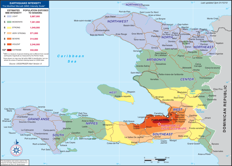
| Descrición | Intensity map for the 2010 Haiti earthquake | |||
| Data | ||||
| Orixe | USAID Haiti earthquake page (direct PDF URL [1]) | |||
| Autoría | USAID | |||
| Licenza (Reuso deste ficheiro) |
|

Historial do ficheiro
Prema nunha data/hora para ver o ficheiro tal e como estaba nese momento.
| Data/Hora | Miniatura | Dimensións | Usuario | Comentario | |
|---|---|---|---|---|---|
| actual | 16 de xaneiro de 2010 ás 09:37 | | 744 × 533 (1,52 MB) | Clindberg | {{Information |Description=Intensity map for the 2010 Haiti earthquake |Source=[http://www.usaid.gov/locations/latin_america_caribbean/country/haiti/eq/ USAID Haiti earthquake page] (direct PDF URL [http://www.usaid.gov/locatio |
Uso do ficheiro
A seguinte páxina usa este ficheiro:
Uso global do ficheiro
Os seguintes wikis empregan esta imaxe:
- Uso en ar.wikipedia.org
- Uso en ast.wikipedia.org
- Uso en es.wikipedia.org
- Uso en fr.wikipedia.org
- Uso en qu.wikipedia.org
- Uso en ro.wikipedia.org
- Uso en sl.wikipedia.org
- Uso en sr.wikipedia.org