Ficheiro:1805 Cary Map of Egypt - Geographicus - Egypt-cary-1805.jpg

Ficheiro orixinal(5.000 × 4.455 píxeles; tamaño do ficheiro: 6,45 MB; tipo MIME: image/jpeg)

John Cary: A New Map of Egypt, from the Latest Authorities.   (Wikidata search (Cirrus search) Wikidata query (SPARQL)  Create new Wikidata item based on this file)
Artista
John Cary  (1755–1835)  wikidata:Q3446124 s:en:Author:John Cary
 
Nomes alternativos
J. Cary
Descrición cartógrafo, gravador, mapseller, printseller e globe maker
Datas de nacemento e morte 23 de febreiro de 1755 Editar isso no Wikidata 16 de agosto de 1835 Editar isso no Wikidata
Lugares de nacemento e morte Corsley Mortlake
Período de actividade 1779 Editar isso no Wikidata–1835 Editar isso no Wikidata
Lugar de traballo
Control de autoridade
artist QS:P170,Q3446124
Título
A New Map of Egypt, from the Latest Authorities.
Descrición
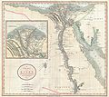
English: An exceptionally beautiful example of John Cary’s important 1805 Map of the Egypt. Covers Egypt in extraordinary detail focusing on the course of the Nile River Valley from the Delta region south to Aswan. Notes the sites of numerous riverside villages and cities as well as important ancient Egyptian ruins, Coptic and Abyssinian Monasteries, and important caravan routes between important desert oases. Also notes the locations of both Mt. Horeb and Mount Sinai, in the Sinai Peninsula. The left hand side of the map is dominated by a large inset of the Nile Delta region. This wonderful inset offers details on ancient ruins and European explorations in the region as well as noting numerous delta cities, villages, and trade routes. All in all, one of the most interesting and attractive atlas maps of Egypt to appear in first years of the 19th century. Prepared in 1805 by John Cary for issue in his magnificent 1808 New Universal Atlas .
Data 1805 (dated)
Dimensións altura: 19,2 pulgadas (48,8 cm); ancho: 21,5 pulgadas (54,6 cm)
dimensions QS:P2048,19.25U218593
dimensions QS:P2049,21.5U218593
Número de acceso
Geographicus link: Egypt-cary-1805
Orixe/Fotógrafo

Cary, John, Cary's New Universal Atlas, containing distinct maps of all the principal states and kingdoms throughout the World. From the latest and best authorities extant. London: Printed for J. Cary, Engraver and Map-seller, No. 181, near Norfolk Street, Strand, 1808.

Licenza
(Reuso deste ficheiro)
Esta é unha reproducción fotográfica fiel dunha obra de arte bidimensional no dominio público. A obra de arte en si mesma atópase no dominio público polo seguinte motivo:
Public domain

Este material está no dominio público nos demais países onde os dereitos de autor se estenden por 100 anos (ou menos) trala morte do autor.


Debe incluír tamén unha etiqueta de dominio público dos Estados Unidos para indicar por que esta obra se atopa no dominio público nos Estados Unidos.
A posición oficial da Fundación Wikimedia é que "as reproducións fieis de obras de arte bidimensionais no dominio público atópanse en si mesmas no dominio público".
Esta reprodución fotográfica considérase polo tanto no dominio público.
Noutras xurisdicións a reutilización deste contido pode estar rextrinxida; vexa Reutilización de fotografías PD-Art para máis información.
Outras versións

}}

Pés de foto

Engada unha explicación dunha liña do representa este ficheiro

Elementos retratados neste ficheiro

representa a

3138f03576be6151944a3f8217bc2ab9c51becd1

tamanho dos dados portugués

6.763.542 Byte

4.455 píxel

5.000 píxel

Historial do ficheiro

Prema nunha data/hora para ver o ficheiro tal e como estaba nese momento.

Data/HoraMiniaturaDimensiónsUsuarioComentario
actual22 de marzo de 2011 ás 10:34Miniatura da versión ás 10:34 do 22 de marzo de 20115.000 × 4.455 (6,45 MB)BotMultichillT{{subst:User:Multichill/Geographicus |link=http://www.geographicus.com/P/AntiqueMap/Egypt-cary-1805 |product_name=1805 Cary Map of Egypt |map_title=A New Map of Egypt, from the Latest Authorities. |description=An exceptionally beautiful example of John Ca

Uso global do ficheiro

Os seguintes wikis empregan esta imaxe: