Ficheiro:Tornado Alley.gif
Non se pode ver nunha resolución meirande.
Tornado_Alley.gif (742 × 582 píxeles; tamaño do ficheiro: 97 kB; tipo MIME: image/gif)
| Este ficheiro procede de Wikimedia Commons. A continuación móstrase a información da súa páxina de descrición. Commons é un repositorio libre de ficheiros multimedia. Pode contribuír alí cargando as súas imaxes. |

|
File:Tornado Alley.svg é unha versión vectorial deste ficheiro. Debería usarse esa versión no canto desta imaxe rasterizada cando sexa de mellor calidade.
File:Tornado Alley.gif → File:Tornado Alley.svg
Para obter máis información acerca de gráficos vectoriais, vaia á páxina sobre a transición a SVG en Commons. Tamén hai información sobre o soporte de MediaWiki de imaxes SVG. |
 |
Resumo
| Descrición |
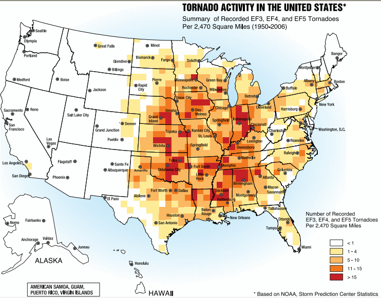
English: A map of the frequency of F3 and greater intensity tornadoes by area. The darker colors highlight the areas typically known as a Tornado Alley. |
| Data | |
| Orixe | Image from Federal Emergency Management Agency, a United States government agency, booklet FEMA 320 Third Edition, Section 1, Figure 1.1, page 3, titled Taking Shelter from the Storm: Building a Safe Room Inside your House |
| Autoría | FEMA personnel |
Licenza
This image is a work of a Federal Emergency Management Agency employee, taken or made as part of that person's official duties. As works of the U.S. federal government, all FEMA images are in the public domain in the United States. Additional media usage information may be found at https://www.fema.gov/photo-video-audio-use-guidelines
|
Historial do ficheiro
Prema nunha data/hora para ver o ficheiro tal e como estaba nese momento.
| Data/Hora | Miniatura | Dimensións | Usuario | Comentario | |
|---|---|---|---|---|---|
| actual | 2 de outubro de 2013 ás 17:25 | | 742 × 582 (97 kB) | Nodove | Greater city name resolution. |
| 4 de febreiro de 2007 ás 17:13 |  | 550 × 406 (67 kB) | TCY | A map of the frequency of F3 and greater intensity tornadoes by area. The darker colors highlight the area typically known as Tornado Alley. '''Source:''' Image from a booklet from [http://www.fema.gov/index.shtm |
Uso do ficheiro
As seguintes 2 páxinas usan este ficheiro:
Uso global do ficheiro
Os seguintes wikis empregan esta imaxe:
- Uso en af.wikipedia.org
- Uso en ast.wikipedia.org
- Uso en ba.wikipedia.org
- Uso en ca.wikipedia.org
- Uso en de.wikipedia.org
- Uso en en.wikipedia.org
- Uso en en.wikibooks.org
- Uso en es.wikipedia.org
- Uso en eu.wikipedia.org
- Uso en fa.wikipedia.org
- Uso en fr.wikipedia.org
- Uso en he.wikivoyage.org
- Uso en hu.wikipedia.org
- Uso en it.wikipedia.org
- Uso en ja.wikipedia.org
- Uso en lt.wikipedia.org
- Uso en nl.wikipedia.org
- Uso en pl.wikipedia.org
- Uso en pt.wikipedia.org
- Uso en ru.wikipedia.org
- Uso en simple.wikipedia.org
- Uso en sl.wikipedia.org
- Uso en sv.wikipedia.org
- Uso en uk.wikipedia.org
- Uso en zh.wikipedia.org