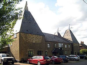
Higham, Kent
Higham é unha parroquia civil e vila do distrito de Gravesham, no condado de Kent (Inglaterra).
| Localización | ||||
|---|---|---|---|---|
| ||||
| Estado | Reino Unido | |||
| País | Inglaterra | |||
| Rexións | Sudeste de Inglaterra - South East England | |||
| Condado cerimonial | Kent | |||
| Condado não-metropolitano (pt) | Kent (en) | |||
| Município (pt) | Gravesham (pt) | |||
| Xeografía | ||||
| Bañado por | Río Támesis | |||
| Identificador descritivo | ||||
| Código postal | ME3 | |||
| Prefixo telefónico | 01474 | |||
Xeografía
editarSegundo a Oficina Nacional de Estatística británica, Higham ten unha superficie de 13,22 km².[1]
Notas
editar- ↑ Tablas: «Usual Resident Population (KS01) for Amalgamated Parishes», «Ethnic Group (KS06) for Amalgamated Parishes», «Country of Birth (KS05) for Amalgamated Parishes» e «Religion (KS07) for Amalgamated Parishes», dispoñibles para descarga aquí Arquivado 08 de setembro de 2011 en Wayback Machine.. Office for National Statistics (en inglés).
Véxase tamén
editar| Wikimedia Commons ten máis contidos multimedia na categoría: Higham, Kent |

