Ficheiro:Arabian Plate showing general tectonic and structural features, Infracambrian rift salt basins, and oil and gas fields of Central Arabia and North Gulf area.svg

Tamaño desta vista previa en PNG do ficheiro en formato SVG: 653 × 469 píxeles. Outras resolucións: 320 × 230 píxeles | 640 × 460 píxeles | 1.024 × 735 píxeles | 1.280 × 919 píxeles | 2.560 × 1.839 píxeles.
Ficheiro orixinal (ficheiro SVG; resolución de 653 × 469 píxeles; tamaño do ficheiro: 76 kB)
| Este ficheiro procede de Wikimedia Commons. A continuación móstrase a información da súa páxina de descrición. Commons é un repositorio libre de ficheiros multimedia. Pode contribuír alí cargando as súas imaxes. |
Resumo
| Descrición |
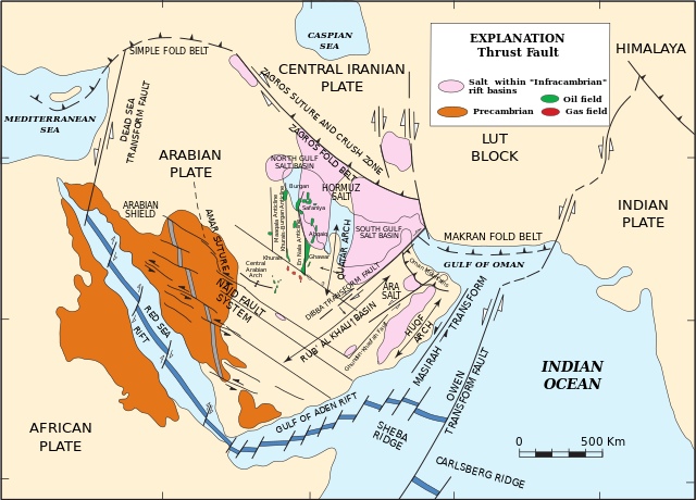
English: Arabian Plate showing general tectonic and structural features, Infracambrian rift salt basins, and oil and gas fields of Central Arabia and North Gulf area |
| Data | |
| Orixe | Pollastro, R.M. (2003) "Total Petroleum Systems of the Paleozoic and Jurassic, Greater Ghawar Uplift and Adjoining Provinces of Central Saudi Arabia and Northern Arabian-Persian Gulf", U.S. Geological Survey Bulletin 2202-H. https://pubs.usgs.gov/bul/b2202-h/b2202-h.pdf, page 14. |
| Autoría | Richard M. Pollastro |
Licenza
Esta imaxe está no dominio público, xa que contén materiais que orixinalmente viñeron do Servizo Xeolóxico dos Estados Unidos de América, unha axencia do Departamento do Interior dos Estados Unidos de América. Para obter máis información, consulta a política oficial de dereitos de USGS.
|
Historial do ficheiro
Prema nunha data/hora para ver o ficheiro tal e como estaba nese momento.
| Data/Hora | Miniatura | Dimensións | Usuario | Comentario | |
|---|---|---|---|---|---|
| actual | 21 de marzo de 2023 ás 22:03 | | 653 × 469 (76 kB) | Sette-quattro | texts as objects |
| 10 de marzo de 2023 ás 13:53 |  | 512 × 396 (289 kB) | Sette-quattro | Uploaded a work by https://pubs.usgs.gov/bul/b2202-h/b2202-h.pdf from https://pubs.usgs.gov/bul/b2202-h/b2202-h.pdf with UploadWizard |
Uso do ficheiro
Non hai páxinas que usen este ficheiro.
Uso global do ficheiro
Os seguintes wikis empregan esta imaxe:
- Uso en de.wikipedia.org
- Uso en en.wikipedia.org