Ficheiro:1853 Mitchell Map of Turkey in Europe and Greece ( Greece, Balkans, Macedonia ) - Geographicus - TurkeyEurope-mitchell-1850.jpg

Tamaño desta vista previa: 489 × 600 píxeles. Outras resolucións: 196 × 240 píxeles | 391 × 480 píxeles | 626 × 768 píxeles | 834 × 1.024 píxeles | 2.445 × 3.000 píxeles.
Ficheiro orixinal (2.445 × 3.000 píxeles; tamaño do ficheiro: 2,91 MB; tipo MIME: image/jpeg)
| Este ficheiro procede de Wikimedia Commons. A continuación móstrase a información da súa páxina de descrición. Commons é un repositorio libre de ficheiros multimedia. Pode contribuír alí cargando as súas imaxes. |
_-_Geographicus_-_TurkeyEurope-mitchell-1850.jpg)
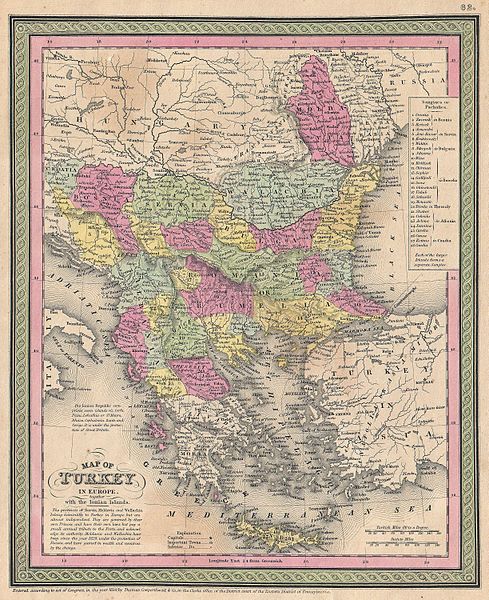
| Samuel Augustus Mitchell: Map of Turkey in Europe together with the Ionian Islands.
( |
||||||||||||||||||||
|---|---|---|---|---|---|---|---|---|---|---|---|---|---|---|---|---|---|---|---|---|
| Artista |
|
|||||||||||||||||||
| Título |
Map of Turkey in Europe together with the Ionian Islands. |
|||||||||||||||||||
| Descrición |
English: An extremely attractive example of S. A. Mitchell Sr.’s 1853 map of Turkey in Europe. This map, made when the Ottoman Empire controlled much of the region, covers what is today Turkey, Greece, Macedonia Croatia, Bosnia, Serbia, Romania, Bulgaria, Macedonia and Albania. Ottoman provinces are color coded and numbered. Surrounded by the green border common to Mitchell maps from the 1850s. Prepared by S. A. Mitchell for issued as plate no. 62 in the 1853 edition of his New Universal Atlas . Dated and copyrighted, “Entered according to act of Congress, in the year 1850, by Thomas Cowperthwait & Co., in the Clerks office of the District court of the Eastern District of Pennsylvania. |
|||||||||||||||||||
| Data | 1850 (dated) | |||||||||||||||||||
| Dimensións | altura: 12,5 pulgadas (31,7 cm); ancho: 10 pulgadas (25,4 cm) | |||||||||||||||||||
| Número de acceso |
Geographicus link: TurkeyEurope-mitchell-1850 |
|||||||||||||||||||
| Orixe/Fotógrafo |
A New Universal Atlas Containing Maps of the various Empires, Kingdoms, States and Republics Of The World. (1853 issue)
|
|||||||||||||||||||
| Licenza (Reuso deste ficheiro) |
|
|||||||||||||||||||
Historial do ficheiro
Prema nunha data/hora para ver o ficheiro tal e como estaba nese momento.
| Data/Hora | Miniatura | Dimensións | Usuario | Comentario | |
|---|---|---|---|---|---|
| actual | 22 de marzo de 2011 ás 13:46 | | 2.445 × 3.000 (2,91 MB) | BotMultichillT | {{subst:User:Multichill/Geographicus |link=http://www.geographicus.com/P/AntiqueMap/TurkeyEurope-mitchell-1850 |product_name=1853 Mitchell Map of Turkey in Europe and Greece ( Greece, Balkans, Macedonia ) |map_title=Map of Turkey in Europe together with t |
Uso do ficheiro
Non hai páxinas que usen este ficheiro.
Uso global do ficheiro
Os seguintes wikis empregan esta imaxe:
- Uso en sh.wikipedia.org
_-_Geographicus_-_TurkeyEurope-mitchell-1850.jpg)