Ficheiro:Zhujiangrivermap.png
Tamaño desta vista previa: 800 × 542 píxeles. Outras resolucións: 320 × 217 píxeles | 640 × 433 píxeles | 988 × 669 píxeles.
Ficheiro orixinal (988 × 669 píxeles; tamaño do ficheiro: 308 kB; tipo MIME: image/png)
| Este ficheiro procede de Wikimedia Commons. A continuación móstrase a información da súa páxina de descrición. Commons é un repositorio libre de ficheiros multimedia. Pode contribuír alí cargando as súas imaxes. |
Resumo
| Descrición |
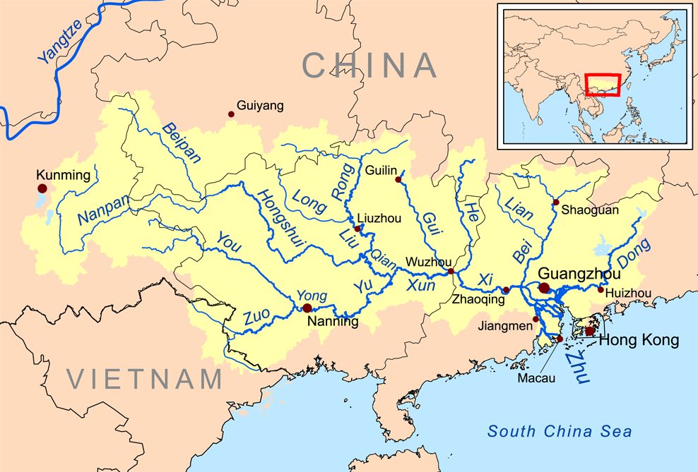
English: Map of the tributaries of the Pearl River, and the Pearl River Basin (watershed/drainage basin) in yellow.
|
| Data | |
| Orixe | Obra propia |
| Autoría | Kmusser |
| Outras versións | estoniano |
Licenza
Eu, como posuidor dos dereitos de autor desta obra, pola presente publícoa baixo a seguinte licenza:
Este ficheiro está licenciado baixo a licenza Creative Commons recoñecemento compartir igual 3.0 sen adaptar.
- Vostede é libre de:
- compartir – copiar, distribuír e difundir a obra
- facer obras derivadas – adaptar a obra
- Baixo as seguintes condicións:
- recoñecemento – Debe indicar a debida atribución de autoría, fornecer unha ligazón á licenza e indicar se se realizaron cambios. Pode facer isto de calquera forma razoable, mais non nunha forma que indique que quen posúe a licenza apoia ou subscribe o seu uso da obra.
- compartir igual – Se altera, transforma ou amplía este contido, debe publicar as súas contribucións baixo a mesma licenza ou outra compatible á orixinal.
Historial do ficheiro
Prema nunha data/hora para ver o ficheiro tal e como estaba nese momento.
| Data/Hora | Miniatura | Dimensións | Usuario | Comentario | |
|---|---|---|---|---|---|
| actual | 21 de decembro de 2015 ás 13:59 | | 988 × 669 (308 kB) | Ras67 | cropped |
| 19 de novembro de 2008 ás 20:09 |  | 1.000 × 681 (346 kB) | Kmusser | {{Information |Description=This is a map of the Pearl River drainage basin. |Source=Own work using http://www.maproom.psu.edu/dcw/ Digital Chart of the World and [[http://edc.usgs.gov/products/elevation/gtopo30/gtopo30.html |
Uso do ficheiro
A seguinte páxina usa este ficheiro:
Uso global do ficheiro
Os seguintes wikis empregan esta imaxe:
- Uso en af.wikipedia.org
- Uso en ar.wikipedia.org
- Uso en arz.wikipedia.org
- Uso en ast.wikipedia.org
- Uso en azb.wikipedia.org
- Uso en az.wikipedia.org
- Uso en ba.wikipedia.org
- Uso en be.wikipedia.org
- Uso en bg.wikipedia.org
- Uso en bh.wikipedia.org
- Uso en bn.wikipedia.org
- Uso en ceb.wikipedia.org
- Uso en cs.wikipedia.org
- Uso en da.wikipedia.org
- Uso en de.wikipedia.org
- Uso en en.wikipedia.org
Ollar o uso global deste ficheiro.