Ficheiro:Tribal Kingdom of Samo-sl version.PNG

Tamaño desta vista previa: 601 × 600 píxeles. Outras resolucións: 241 × 240 píxeles | 481 × 480 píxeles | 852 × 850 píxeles.
Ficheiro orixinal (852 × 850 píxeles; tamaño do ficheiro: 149 kB; tipo MIME: image/png)
| Este ficheiro procede de Wikimedia Commons. A continuación móstrase a información da súa páxina de descrición. Commons é un repositorio libre de ficheiros multimedia. Pode contribuír alí cargando as súas imaxes. |
| Descrición |
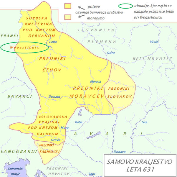
English: Tribal Kingdom of Samo. Map is based on the maps in: Korošec, Paola (1990): Alpski Slovani- Die Alpenslawen, Ljubljana, Znanstveni institut Filozofske fakultete, unnamed map on the page 18; Šavli, Jožko (1995): Sovenija: Podoba evropskega naroda, Bilje, založba Humar, map Samovo kraljestvo on the page 19; Barford, Paul M. (2001): The Early Slavs, Cornell University Press, map on the page 356, named Geography of the Slav settlement of Polabia- concerning the location of Sorbs east of Saale; map IV on page 397 for Sorbian culture, Devinska-Nova ves culture and Avarian state. It is also based on descriptions in: Štih, Peter (2001): Ozemlje Slovenije v zgodnjem srednjem veku: osnovne poteze zgodovinskega razvoja od začetka 6. do konca 9. stoletja, Ljubljana, Filozofska fakulteta; page 30- concerning the relationsship between king Samo and the ancestros of Slovenians; Korošec, Paola (1990): Alpski Slovani- Die Alpenslawen, Ljubljana, Znanstveni institut Filozofske fakultete, page 17 – concerning the Sorbs and their duke Dervan. For eastern and southern extant of tribal kingdom: known territories are shown by the scheme of franco-slavic border and information about the conflicts with Avars is imlemented. The inclusion of Bohemian basin is followed. Contacts with Avars are reached through the territory of Moravians anf Eastern Alps. The territories further east and south, which are in proximity of Avars, could be parts of tribal kingdom, too. |
| Data | (UTC) |
| Orixe | |
| Autoría |
|
| Esta é unha imaxe retocada,en o que significa que a súa versión orixinal foi alterada dixitalmente. Modificacións: The map of Danube basin was used to create map of Kingdom of Samo. A orixinal pódese ver aquí: Waterways of SE Central Europe.svg. As modificacións realizounas Bostjan46.
|
Eu, como posuidor dos dereitos de autor desta obra, pola presente publícoa baixo a seguinte licenza:
| Eu, como posuidor dos dereitos de autor desta obra, libéroa para que pertenza ao dominio público. Isto é válido en todo o mundo. Nalgúns países, isto pode non ser legalmente posible; entón: Concedo a calquera o dereito de empregar esta obra para o propósito que considere oportuno, sen condicións, agás aquelas que sexan requiridas pola lei. |
Rexistro de cargas orixinal
This image is a derivative work of the following images:
- File:Waterways_of_SE_Central_Europe.svg licensed with PD-self
- 2010-01-08T20:49:27Z Kmiki87 1415x1059 (292577 Bytes) {{Information |Description={{en|1=Waterways along the central and lower Danube, including the Bohemian and Carpathian Basins, the northern Balkans, parts of Austria, southern Poland and Western Ukraine.}} |Source={{own}} |Aut
Carregada com derivativeFX
Historial do ficheiro
Prema nunha data/hora para ver o ficheiro tal e como estaba nese momento.
| Data/Hora | Miniatura | Dimensións | Usuario | Comentario | |
|---|---|---|---|---|---|
| actual | 9 de xaneiro de 2011 ás 18:21 | | 852 × 850 (149 kB) | Bostjan46 | The text for Dalmatian Slavs was changed (Slavic tribes under avarian rule>>Ancestors of Croats). |
| 9 de xaneiro de 2011 ás 17:13 |  | 852 × 850 (150 kB) | Bostjan46 | {{Information |Description={{en|1=Tribal Kingdom of Samo. Map is based on the maps in: Korošec, Paola (1990): ''Alpski Slovani- Die Alpenslawen'', Ljubljana, Znanstveni institut Filozofske fakultete, unnamed map on the page 18; Šavli, Jožko (1995): '' |
Uso do ficheiro
A seguinte páxina usa este ficheiro:
Uso global do ficheiro
Os seguintes wikis empregan esta imaxe:
- Uso en az.wikipedia.org
- Uso en be.wikipedia.org
- Uso en bg.wikipedia.org
- Uso en de.wikipedia.org
- Uso en lt.wikipedia.org
- Uso en pl.wikipedia.org
- Uso en ru.wikipedia.org
- Uso en sl.wikipedia.org
- Uso en sr.wikipedia.org
- Uso en sv.wikipedia.org
- Uso en szl.wikipedia.org