Ficheiro:The Man in the High Castle Plausible World Map.png
Tamaño desta vista previa: 800 × 579 píxeles. Outras resolucións: 320 × 232 píxeles | 640 × 463 píxeles | 1.024 × 741 píxeles | 1.280 × 926 píxeles | 1.577 × 1.141 píxeles.
Ficheiro orixinal (1.577 × 1.141 píxeles; tamaño do ficheiro: 400 kB; tipo MIME: image/png)
| Este ficheiro procede de Wikimedia Commons. A continuación móstrase a información da súa páxina de descrición. Commons é un repositorio libre de ficheiros multimedia. Pode contribuír alí cargando as súas imaxes. |

|
This map, as well as other fictitious maps, is fictitious or too incorrect (i.e. due to anachronism) to be used in real-life contexts (contemporary or historic). It may have some visual elements that are similar to official maps such as colors or certain layout features, but they are NOT official and don't have any official recognition. |
[[Category:]]
Resumo
| Descrición |
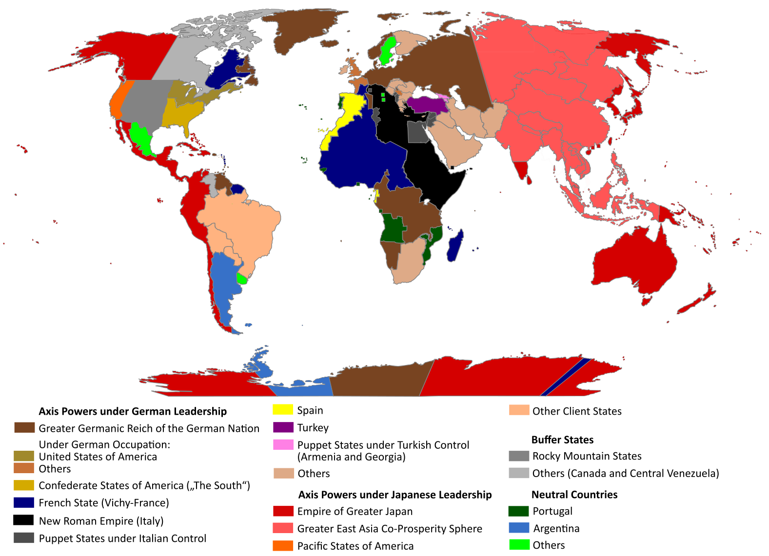
English: "The Man in the High Castle" is an alternate history novel by Philip K. Dick. It is set in a world in which the Axis powers have won World War II. This map is inspired by Dick's story and shows a plausible division of the world between Nazi Germany (dark brown), Imperial Japan (dark red) and their respective allies. However, the map is much more precise than the book describes.
https://web.archive.org/web/20191202005150/http://www.high-castle-world-map.com:80/ |
| Data | |
| Orixe | Obra propia |
| Autoría | RobintheHighCastle |
| Licenza (Reuso deste ficheiro) |
Licenza
Eu, como posuidor dos dereitos de autor desta obra, pola presente publícoa baixo a seguinte licenza:
Este ficheiro está licenciado baixo a licenza Creative Commons recoñecemento compartir igual 4.0 internacional.
- Vostede é libre de:
- compartir – copiar, distribuír e difundir a obra
- facer obras derivadas – adaptar a obra
- Baixo as seguintes condicións:
- recoñecemento – Debe indicar a debida atribución de autoría, fornecer unha ligazón á licenza e indicar se se realizaron cambios. Pode facer isto de calquera forma razoable, mais non nunha forma que indique que quen posúe a licenza apoia ou subscribe o seu uso da obra.
- compartir igual – Se altera, transforma ou amplía este contido, debe publicar as súas contribucións baixo a mesma licenza ou outra compatible á orixinal.
Historial do ficheiro
Prema nunha data/hora para ver o ficheiro tal e como estaba nese momento.
| Data/Hora | Miniatura | Dimensións | Usuario | Comentario | |
|---|---|---|---|---|---|
| actual | 29 de outubro de 2021 ás 14:55 | | 1.577 × 1.141 (400 kB) | Saltner67 | Added the portoguese colonies Cabinda and Ajuda since they would still have existed in this world. |
| 20 de xuño de 2021 ás 08:05 |  | 1.613 × 1.143 (417 kB) | Gernsback67 | Changed "Greater Asian Co-Prosperity Sphere" in "Greater East Asia Co-Prosperity Sphere", which is correct. | |
| 16 de outubro de 2020 ás 15:30 |  | 1.611 × 1.138 (418 kB) | Saltner67 | Restored the latest version. Please do not revert any changes, which have been made to this file so far, without any communication with the author of the map. All changes made here have been initialized by the author and are a result of the same process which has led to the creation of the map in the first place. | |
| 16 de outubro de 2020 ás 08:25 |  | 1.621 × 1.137 (392 kB) | Gooduserdude | RV Original research: this image is based on a source and should not be altered | |
| 29 de marzo de 2020 ás 14:15 |  | 1.611 × 1.138 (418 kB) | Saltner67 | Improved the accuracy of borders of Mongolia and Manchukuo. | |
| 27 de marzo de 2020 ás 15:58 |  | 1.607 × 1.138 (418 kB) | Saltner67 | Enlarged Manchukuo and added the puppet states of Yakutia and Krasnoyarsk/Irkutsk after more research on Kantokuen. | |
| 12 de marzo de 2020 ás 19:07 |  | 1.612 × 1.143 (411 kB) | Saltner67 | Moved the Swiss Canton of Valais from Germany to Italy, as has been prepared in the plans for Operation Tannenbaum. | |
| 8 de febreiro de 2020 ás 18:57 |  | 1.605 × 1.139 (411 kB) | Saltner67 | Reinserted the territories of Tunisia,Greece, Crete and Cyprus after research on the Italian plannings and Greece in WWII. | |
| 21 de novembro de 2019 ás 13:21 |  | 1.611 × 1.133 (409 kB) | Gernsback67 | Enlarged Mongolia again after more research on pan-mongolism. | |
| 21 de setembro de 2019 ás 15:13 |  | 1.610 × 1.137 (408 kB) | Saltner67 | unified Mongolia, enlarged Manchukuo and Thailand, re-inserted the real-life borders of Laos and Vietnam after research on Demchugdongrub, Kantokuen, Thailand and Indochina in WWII |
Uso do ficheiro
A seguinte páxina usa este ficheiro:
Uso global do ficheiro
Os seguintes wikis empregan esta imaxe:
- Uso en ar.wikipedia.org
- Uso en cs.wikipedia.org
- Uso en da.wikipedia.org
- Uso en de.wikipedia.org
- Uso en en.wikipedia.org
- Uso en en.wikiquote.org
- Uso en es.wikipedia.org
- Uso en he.wikipedia.org
- Uso en hu.wikipedia.org
- Uso en it.wikipedia.org
- Uso en ja.wikipedia.org
- Uso en ko.wikipedia.org
- Uso en lt.wikipedia.org
- Uso en nl.wikipedia.org
- Uso en pl.wikipedia.org
- Uso en pt.wikipedia.org
- Uso en ro.wikipedia.org
- Uso en ru.wikipedia.org
- Uso en th.wikipedia.org
- Uso en uk.wikipedia.org
- Uso en zh-classical.wikipedia.org
- Uso en zh.wikipedia.org