Ficheiro:Tetiaroa.jpg
Ficheiro orixinal (617 × 668 píxeles; tamaño do ficheiro: 111 kB; tipo MIME: image/jpeg)
| Este ficheiro procede de Wikimedia Commons. A continuación móstrase a información da súa páxina de descrición. Commons é un repositorio libre de ficheiros multimedia. Pode contribuír alí cargando as súas imaxes. |
Resumo
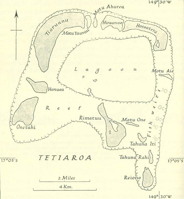
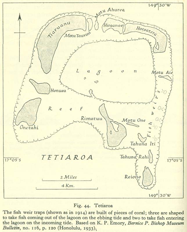
http://www.lib.utexas.edu/maps/historical/pacific_islands_1943_1945/tetiaroa.jpg
Public domain, as explained on page http://www.lib.utexas.edu/usage_statement.html?maps=yes: "Most of the maps scanned by the University of Texas Libraries and served from this web site are in the public domain. No permissions are needed to copy them. You may download them and use them as you wish. A few maps are copyrighted, and are clearly marked as such."
The motu of Tahuna Iti and the sandbank of Motu One are interchanged on the map.
Licenza
Este ficheiro encontra-se no domínio público, porque it has been taken from a collection of public domain maps at the University of Texas Library''
Em alguns países isto não é legalmente possível, neste caso: Por favor, verifique que a razão acima dada é válida!
|
Historial do ficheiro
Prema nunha data/hora para ver o ficheiro tal e como estaba nese momento.
| Data/Hora | Miniatura | Dimensións | Usuario | Comentario | |
|---|---|---|---|---|---|
| actual | 18 de xaneiro de 2014 ás 08:00 | | 617 × 668 (111 kB) | Cropbot | upload cropped version, operated by User:Andy king50. Summary: cropped |
| 21 de outubro de 2006 ás 15:23 |  | 644 × 797 (92 kB) | Ratzer | http://www.lib.utexas.edu/maps/historical/pacific_islands_1943_1945/tetiaroa.jpg Public domain, as explained on page http://www.lib.utexas.edu/usage_statement.html?maps=yes: "Most of the maps scanned by the University of Texas Libraries and served from t |
Uso do ficheiro
A seguinte páxina usa este ficheiro:
Uso global do ficheiro
Os seguintes wikis empregan esta imaxe:
- Uso en als.wikipedia.org
- Uso en az.wikipedia.org
- Uso en ca.wikipedia.org
- Uso en de.wikipedia.org
- Uso en en.wikipedia.org
- Uso en eo.wikipedia.org
- Uso en es.wikipedia.org
- Uso en fr.wikipedia.org
- Uso en hu.wikipedia.org
- Uso en mk.wikipedia.org
- Uso en no.wikipedia.org
- Uso en pl.wikipedia.org
- Uso en pt.wikipedia.org
- Uso en ru.wikipedia.org
- Uso en sv.wikipedia.org
- Uso en zh.wikipedia.org