Ficheiro:Senkaku-uotsuri.jpg
Tamaño desta vista previa: 800 × 390 píxeles. Outras resolucións: 320 × 156 píxeles | 831 × 405 píxeles.
Ficheiro orixinal (831 × 405 píxeles; tamaño do ficheiro: 208 kB; tipo MIME: image/jpeg)
| Este ficheiro procede de Wikimedia Commons. A continuación móstrase a información da súa páxina de descrición. Commons é un repositorio libre de ficheiros multimedia. Pode contribuír alí cargando as súas imaxes. |
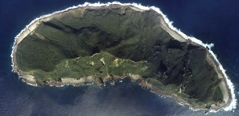
- 尖閣諸島魚釣島の航空写真
- Uotsuri-jima, Senkaku Islands, Japan
- This is a composite picture of four aerial photos. Sources are [5],[6],[7], and [8]. They are all taken in 1978 by Japanese government.

|
O propietario dos dereitos de autor deste ficheiro, the Ministry of Land, Infrastructure, Transport and Tourism of Japan, permite que calquera poida usalo para calquera propósito, sempre e cando se lle recoñeza a autoría a quen cede os dereitos. A redistribución, edición, uso comercial e calquera outro tipo de uso están permitidos. |
Recoñecemento:
Copyright © National Land Image Information (Color Aerial Photographs), Ministry of Land, Infrastructure, Transport and Tourism
|
 |
This image is copyrighted by the Ministry of Land, Infrastructure, Transport and Tourism of Japan. For terms of use, see the stipulation to use of National Land Information (in Japanese) and message from MLIT (in Japanese and English). When you display this image on an article, include the following phrase in the description: "Made based on National Land Image Information (Color Aerial Photographs), Ministry of Land, Infrastructure, Transport and Tourism".
|
Historial do ficheiro
Prema nunha data/hora para ver o ficheiro tal e como estaba nese momento.
| Data/Hora | Miniatura | Dimensións | Usuario | Comentario | |
|---|---|---|---|---|---|
| actual | 25 de setembro de 2005 ás 16:33 | | 831 × 405 (208 kB) | Moja~commonswiki | *尖閣諸島魚釣島の航空写真 *Uotsuri-il, Senkaku Islands, Japan {{GFDL-AerialPhoto-MlitJp}} |
Uso do ficheiro
A seguinte páxina usa este ficheiro:
Uso global do ficheiro
Os seguintes wikis empregan esta imaxe:
- Uso en ar.wikipedia.org
- Uso en bg.wikipedia.org
- Uso en bn.wikipedia.org
- Uso en ca.wikipedia.org
- Uso en cs.wikipedia.org
- Uso en cy.wikipedia.org
- Uso en da.wikipedia.org
- Uso en de.wikipedia.org
- Uso en en.wikipedia.org
- Uso en es.wikipedia.org
- Uso en fa.wikipedia.org
- Uso en fr.wikipedia.org
- Uso en gan.wikipedia.org
- Uso en hak.wikipedia.org
- Uso en hy.wikipedia.org
- Uso en id.wikipedia.org
- Uso en ja.wikipedia.org
- Uso en ja.wikibooks.org
- Uso en ko.wikipedia.org
- Uso en ms.wikipedia.org
- Uso en nl.wikipedia.org
- Uso en nn.wikipedia.org
- Uso en no.wikipedia.org
- Uso en pl.wikipedia.org
- Uso en pt.wikipedia.org
- Uso en ro.wikipedia.org
- Uso en ru.wikipedia.org
- Uso en sv.wikipedia.org
- Uso en ta.wikipedia.org
- Uso en th.wikipedia.org
Ollar o uso global deste ficheiro.