Ficheiro:Santa-barbara-island-nps-map.PNG
Non se pode ver nunha resolución meirande.
Santa-barbara-island-nps-map.PNG (485 × 425 píxeles; tamaño do ficheiro: 16 kB; tipo MIME: image/png)
| Este ficheiro procede de Wikimedia Commons. A continuación móstrase a información da súa páxina de descrición. Commons é un repositorio libre de ficheiros multimedia. Pode contribuír alí cargando as súas imaxes. |
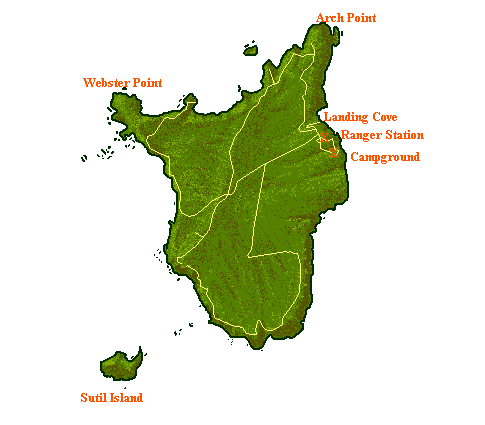
Resumo
- NPS map of Santa Barbara Island — in Channel Islands National Park, Southern California.
- Showing campgrounds, trails, access coves, and adjacent islets.
converted from .gif into .png format
| This image or media file contains material based on a work of a National Park Service employee, created as part of that person's official duties. As a work of the U.S. federal government, such work is in the public domain in the United States. See the NPS website and NPS copyright policy for more information. |
Historial do ficheiro
Prema nunha data/hora para ver o ficheiro tal e como estaba nese momento.
| Data/Hora | Miniatura | Dimensións | Usuario | Comentario | |
|---|---|---|---|---|---|
| actual | 20 de maio de 2009 ás 14:04 | | 485 × 425 (16 kB) | Telim tor | NPS map of Santa Barbara Island, converted from .gif into .png format {{PD-USGov-NPS}} Category:Santa Barbara Island Category:Channel Islands National Park Category:Maps of California <!--{{ImageUpload|basic}}--> |
Uso do ficheiro
A seguinte páxina usa este ficheiro:
Uso global do ficheiro
Os seguintes wikis empregan esta imaxe:
- Uso en en.wikipedia.org
- Uso en it.wikipedia.org
- Uso en nl.wikipedia.org
- Uso en pl.wikipedia.org