Ficheiro:Rzeczpospolita Royal Ducal.png
Non se pode ver nunha resolución meirande.
Rzeczpospolita_Royal_Ducal.png (686 × 508 píxeles; tamaño do ficheiro: 144 kB; tipo MIME: image/png)
| Este ficheiro procede de Wikimedia Commons. A continuación móstrase a información da súa páxina de descrición. Commons é un repositorio libre de ficheiros multimedia. Pode contribuír alí cargando as súas imaxes. |

|
Esta imaxe (ou todas as imaxes deste artigo ou categoría) deberían volverse crear como imaxes vectoriais SVG. Isto proporciona moitas vantaxes, véxase Commons:Media for cleanup (en inglés) para máis información. Se xa hai unha versión SVG desta imaxe dispoñible, por favor, cárguea en Commons. Tras subila, substitúa este modelo polo modelo {{vector version available|novo nome da imaxe.svg}} nesta imaxe.
|
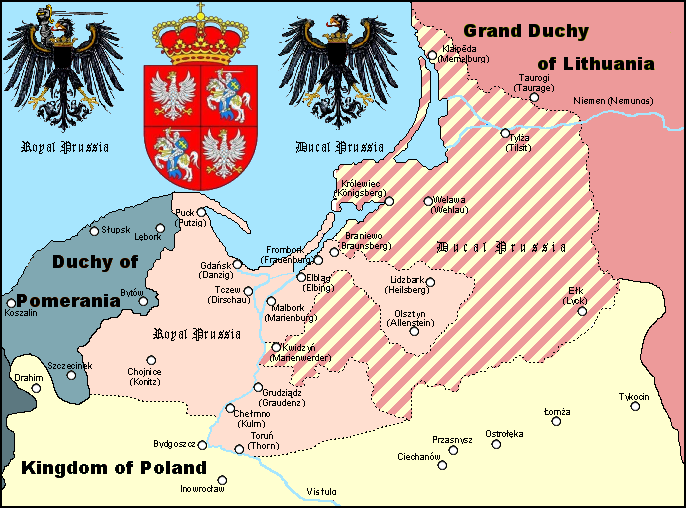
Resumo
A Polish Wikipedian made version of Royal and Ducal Prussia around 1575.
Made by Halibutt in GIMP, based on an earlier GFDL map by w:User:Space Cadet and Halibutt's "Rzeczpospolita" map series.
| Kingdom of Poland | Since 1569 Polish-Lithuanian Commonwealth | |
| Grand Duchy of Lithuania | Since 1569 Polish-Lithuanian Commonwealth | |
| Royal Prussia | Pomeranian, Malbork, Chełmno Voivodships and bishopry of Warmia | |
| Ducal Prussia | Polish fief | |
| Duchy of Pomerania | Part of the Holy Roman Empire (since 1600s: "...of the German Nation") | |
| Brandenburg | Part of the Holy Roman Empire (since 1600s: "...of the German Nation") |

|
A información de texto que estaba inserida na imaxe foi retirada e movida para súa páxina de descrición ou para súa sección de metadatos. Isto facilita súa utilización e comprensión en varios idiomas, ademais de permitir o seu sinxelo procesamento e posterior busca. Commons desaconsella o uso de marcas de auga nas imaxes co fin de identificar a autoría ou licenza. Se vostede non desexa que a súa imaxe sexa usada sen marca de auga, solicite que sexa eliminada.
|
Licenza
Since the legal status of the above comment has been questioned, I hereby grant anyone the right to treat it as either a standard copyright notice, invariant section, legal statement, legal advice, friendly suggestion or a mere comment, depending on his or hers own choice. |
|

The following is a list of maps created by Halibutt and uploaded to commons, as well as their present and projected derivatives.
| Parent Image | Image | Description | |||||||||||
|---|---|---|---|---|---|---|---|---|---|---|---|---|---|
| Maps by Halibutt | |||||||||||||
| Image:Rzeczpospolita.png | Image:Rzeczpospolita.png | The Republic in 17th and 18th century | |||||||||||
| Image:Rzeczpospolita 1600.png | The Republic after the Treaty of Dywilino | ||||||||||||
| Image:Rzeczpospolita voivodships.png | Voivodships of The Republic | ||||||||||||
| Image:Rzeczpospolita_Potop.png | The Republic during The Deluge and Chmielnicki Uprising, with major battles of the era marked | ||||||||||||
| Magnates and their lands and domains | |||||||||||||
| 1st • 2nd • 3rd | Partitions of Poland | ||||||||||||
| War of the constitution | |||||||||||||
| Image:Rzeczpospolita.xcf | SOURCE FILE - GIMP format | ||||||||||||
| Image:Poland 1939.png | Image:Poland 1939.png | Poland in 1939 | |||||||||||
| Image:Dywizje wrzesien 1.png | Order of Battle on September 1st, during the Polish Defence War of 1939 | ||||||||||||
| Image:Poland 1939.xcf | SOURCE FILE - GIMP format | ||||||||||||
| Image:Polska kontur bialy.png | Image:Polska kontur bialy.png | Contour map of Poland AD 1999, for use with various locator maps | |||||||||||
| Image:Rzeczpospolita 1923.png | Image:Rzeczpospolita 1923.png | Map of Poland 1918-1939, currently under development | |||||||||||
| Image:PBW March 1919.png | Polish-Bolshevik War - fronts in March of 1919 | ||||||||||||
| Image:PBW December 1919.png | Polish-Bolshevik War - fronts in December of 1919 | ||||||||||||
| Image:PBW June 1920.png | Polish-Bolshevik War - fronts in July of 1920 | ||||||||||||
| Image:PBW August 1920.png | Polish-Bolshevik War - fronts in August of 1920 | ||||||||||||
| Polish Defence War of 1939 | |||||||||||||
| Polish areas annexed by Germany, Lithuania, Slovakia and the Soviet Union | |||||||||||||
| German concentration camps in Poland | |||||||||||||
| Curzon line | |||||||||||||
| Major battles of the Polish-Bolshevik War | |||||||||||||
| names • no names | Polish/Czechoslovak/Lithuanian/German/Ukrainian claims in 1920's | ||||||||||||
| Image:Rzeczpospolita Central Lithuania.png | Central Lithuania | ||||||||||||
| Image:Rzeczpospolita Lithuania claims.png | Central Lithuania as compared with other Lithuanian claims | ||||||||||||
| Image:Rzeczpospolita 1789-1920.png | Post-1922 borders compared with the territory of Poland before the partitions | ||||||||||||
| Warsaw Uprising and the Operation Tempest | |||||||||||||
| Poland partitioned between the Soviets and the Germans | |||||||||||||
| Image:Rzeczpospolita 1939 Polish divisions.png | Polish divisions on September 1, 1939 | ||||||||||||
| Home Army inspectorates | |||||||||||||
| Image:Rzeczpospolita 1922.xcf | SOURCE FILE - GIMP format | ||||||||||||
| Image:Rzeczpospolita 1937.svg | Vector version!!!! | layered version available on request | |||||||||||
Historial do ficheiro
Prema nunha data/hora para ver o ficheiro tal e como estaba nese momento.
| Data/Hora | Miniatura | Dimensións | Usuario | Comentario | |
|---|---|---|---|---|---|
| actual | 3 de abril de 2023 ás 12:44 | | 686 × 508 (144 kB) | Natus37 | Wappenkorr. (-rote Flecke) |
| 19 de febreiro de 2013 ás 21:30 |  | 686 × 508 (127 kB) | Jbarta | remove caption, minor fix | |
| 28 de febreiro de 2006 ás 16:27 |  | 686 × 534 (141 kB) | Halibutt | A map of Royal and Ducal Prussia around 1575, made by Halibutt in GIMP, based on an [http://upload.wikimedia.org/wikipedia/en/archive/c/cb/20041019104150%21Royal_Ducal.png earlier GFDL map] by w:User:Space Cadet and Halibutt's "Rzeczpospolita" map se |
Uso do ficheiro
A seguinte páxina usa este ficheiro:
Uso global do ficheiro
Os seguintes wikis empregan esta imaxe:
- Uso en an.wikipedia.org
- Uso en ar.wikipedia.org
- Uso en ast.wikipedia.org
- Uso en az.wikipedia.org
- Uso en be.wikipedia.org
- Uso en ca.wikipedia.org
- Uso en cs.wikipedia.org
- Uso en da.wikipedia.org
- Uso en de.wikipedia.org
- Uso en el.wikipedia.org
- Uso en en.wikipedia.org
- Uso en eo.wikipedia.org
- Uso en et.wikipedia.org
- Uso en fi.wikipedia.org
- Uso en fr.wikipedia.org
- Uso en he.wikipedia.org
- Uso en hu.wikipedia.org
- Uso en id.wikipedia.org
- Uso en it.wikipedia.org
- Uso en ja.wikipedia.org
Ollar o uso global deste ficheiro.