Ficheiro:New Zealand map.PNG
New_Zealand_map.PNG (323 × 590 píxeles; tamaño do ficheiro: 89 kB; tipo MIME: image/png)
| Este ficheiro procede de Wikimedia Commons. A continuación móstrase a información da súa páxina de descrición. Commons é un repositorio libre de ficheiros multimedia. Pode contribuír alí cargando as súas imaxes. |
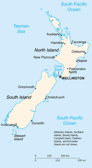
A map of New Zealand showing the major cities and towns. Not shown are the Antipodes Islands, Auckland Islands, Bounty Islands, Campbell Island, The Snares, and the Kermadec Islands.
https://www.cia.gov/library/publications/the-world-factbook/geos/nz.html cópia arquivada at the Wayback Machine
It should be noted that the scale on this map is not accurate. Measuring distances on the map then using the scale to determine those distances on the ground would lead to considerable exaggeration of those distances. This issue has been raised with the CIA, who compile these World Fact Book maps.
- Update - the latest version updated by Grutness is much better. Please see the Talk page for more.
Esta imaxe atópase no dominio público, xa que o seu contido provén do World Factbook, unha publicación da Axencia Central de Intelixencia (CIA) dos Estados Unidos da América.
|
 |
Historial do ficheiro
Prema nunha data/hora para ver o ficheiro tal e como estaba nese momento.
| Data/Hora | Miniatura | Dimensións | Usuario | Comentario | |
|---|---|---|---|---|---|
| actual | 30 de xullo de 2005 ás 01:14 | | 323 × 590 (89 kB) | Grutness | scale corrected |
| 30 de xullo de 2005 ás 01:04 |  | 323 × 590 (100 kB) | Grutness | Scale corrected | |
| 6 de maio de 2005 ás 04:24 |  | 323 × 590 (21 kB) | Evil Monkey | World Factbook map cropped and modified but still PD |
Uso do ficheiro
As seguintes 2 páxinas usan este ficheiro:
Uso global do ficheiro
Os seguintes wikis empregan esta imaxe:
- Uso en an.wikipedia.org
- Uso en bbc.wikipedia.org
- Uso en be-tarask.wikipedia.org
- Uso en br.wikipedia.org
- Uso en bs.wikipedia.org
- Uso en cs.wikipedia.org
- Uso en de.wikipedia.org
- Uso en de.wikinews.org
- Uso en en.wikipedia.org
- Uso en en.wiktionary.org
- Uso en es.wikinews.org
- Uso en eu.wikipedia.org
- Uso en fr.wikipedia.org
- Uso en fr.wiktionary.org
- Uso en gd.wikipedia.org
- Uso en he.wikipedia.org
- Uso en hi.wikipedia.org
- Uso en hr.wikipedia.org
- Uso en io.wikipedia.org
- Uso en it.wikipedia.org
- Uso en ka.wikipedia.org
- Uso en la.wikipedia.org
- Uso en lt.wikipedia.org
- Uso en ml.wikipedia.org
- Uso en mr.wikipedia.org
- Uso en nds-nl.wikipedia.org
- Uso en nl.wikipedia.org
- Uso en nn.wikipedia.org
- Uso en no.wikipedia.org
- Uso en pl.wikipedia.org
- Uso en pl.wikibooks.org
- Uso en pl.wikivoyage.org
- Uso en pt.wikipedia.org
- Uso en ru.wikipedia.org
- Uso en ru.wikinews.org
- Uso en sr.wikipedia.org
- Uso en sv.wikipedia.org
Ollar o uso global deste ficheiro.