Ficheiro:Mar Balear delineada.jpg

Tamaño desta vista previa: 643 × 600 píxeles. Outras resolucións: 257 × 240 píxeles | 514 × 480 píxeles | 823 × 768 píxeles | 1.060 × 989 píxeles.
Ficheiro orixinal (1.060 × 989 píxeles; tamaño do ficheiro: 203 kB; tipo MIME: image/jpeg)
| Este ficheiro procede de Wikimedia Commons. A continuación móstrase a información da súa páxina de descrición. Commons é un repositorio libre de ficheiros multimedia. Pode contribuír alí cargando as súas imaxes. |
Resumo
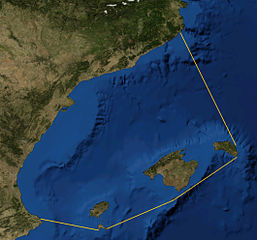
| Descrición |
Català: Foto satèl·lit de la Mar Balear, delineada
Español: Foto satelital del Mar Balear
English: Satellite Picture of the Balearic Sea, delineated |
|||
| Data | ||||
| Orixe | Satellite picture from NASA World Wind Globe, version 1.4; lines my work, based on definition at Limits of Oceans and Seas, 3rd edition by International Hydrographic Organisation. | |||
| Autoría | NASA, Rwxrwxrwx | |||
| Licenza (Reuso deste ficheiro) |
|

Historial do ficheiro
Prema nunha data/hora para ver o ficheiro tal e como estaba nese momento.
| Data/Hora | Miniatura | Dimensións | Usuario | Comentario | |
|---|---|---|---|---|---|
| actual | 30 de setembro de 2014 ás 20:50 | | 1.060 × 989 (203 kB) | Rwxrwxrwx | User created page with UploadWizard |
Uso do ficheiro
A seguinte páxina usa este ficheiro:
Uso global do ficheiro
Os seguintes wikis empregan esta imaxe:
- Uso en bn.wikipedia.org
- Uso en bs.wikipedia.org
- Uso en ca.wikipedia.org
- Uso en co.wikipedia.org
- Uso en da.wikipedia.org
- Uso en de.wikipedia.org
- Uso en en.wikipedia.org
- Uso en es.wikipedia.org
- Uso en eu.wikipedia.org
- Uso en fr.wikipedia.org
- Uso en he.wikipedia.org
- Uso en hr.wikipedia.org
- Uso en ilo.wikipedia.org
- Uso en it.wikipedia.org
- Uso en ja.wikipedia.org
- Uso en nl.wikipedia.org
- Uso en pl.wiktionary.org
- Uso en uk.wikipedia.org