Ficheiro:Map of Ohio NA.png

Tamaño desta vista previa: 800 × 542 píxeles. Outras resolucións: 320 × 217 píxeles | 640 × 434 píxeles | 1.024 × 694 píxeles | 1.280 × 867 píxeles | 1.967 × 1.333 píxeles.
Ficheiro orixinal (1.967 × 1.333 píxeles; tamaño do ficheiro: 2,02 MB; tipo MIME: image/png)
| Este ficheiro procede de Wikimedia Commons. A continuación móstrase a información da súa páxina de descrición. Commons é un repositorio libre de ficheiros multimedia. Pode contribuír alí cargando as súas imaxes. |
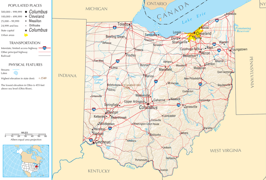
| Descrición | Map of Ohio |
| Orixe | National Atlas |
| Autoría |
This map was obtained from an edition of the National Atlas of the United States. Like almost all works of the U.S. federal government, works from the National Atlas are in the public domain in the United States.
Online access: NationalAtlas.gov | 1970 print edition: Library of Congress, Perry-Castañeda Library
|
Historial do ficheiro
Prema nunha data/hora para ver o ficheiro tal e como estaba nese momento.
| Data/Hora | Miniatura | Dimensións | Usuario | Comentario | |
|---|---|---|---|---|---|
| actual | 30 de agosto de 2007 ás 11:21 | | 1.967 × 1.333 (2,02 MB) | Conscious | cropped |
| 15 de agosto de 2006 ás 08:02 |  | 2.122 × 1.640 (2,17 MB) | Huebi~commonswiki | {{Information| |Description=Map of Ohio |Source=[http://www.nationalatlas.gov National Atlas] }} Category:Maps of the United States Category:Maps of Ohio {{PD-USGov-Atlas}} |
Uso do ficheiro
A seguinte páxina usa este ficheiro:
Uso global do ficheiro
Os seguintes wikis empregan esta imaxe:
- Uso en arz.wikipedia.org
- Uso en de.wikipedia.org
- Uso en en.wikipedia.org
- Uso en es.wikipedia.org
- Uso en eu.wikipedia.org
- Uso en fr.wikipedia.org
- Uso en hr.wiktionary.org
- Uso en hsb.wikipedia.org
- Uso en hu.wikipedia.org
- Uso en incubator.wikimedia.org
- Uso en io.wikipedia.org
- Uso en it.wikipedia.org
- Uso en ja.wikipedia.org
- Uso en kk.wikipedia.org
- Uso en mk.wikipedia.org
- Uso en mr.wikipedia.org
- Uso en nl.wikipedia.org
- Uso en rue.wikipedia.org
- Uso en ru.wikipedia.org
- Uso en stq.wikipedia.org
- Uso en sw.wikipedia.org
- Uso en szl.wikipedia.org
- Uso en zea.wikipedia.org