Ficheiro:Map Denmark Demis SE islands.gif
Non se pode ver nunha resolución meirande.
Map_Denmark_Demis_SE_islands.gif (415 × 420 píxeles; tamaño do ficheiro: 23 kB; tipo MIME: image/gif)
| Este ficheiro procede de Wikimedia Commons. A continuación móstrase a información da súa páxina de descrición. Commons é un repositorio libre de ficheiros multimedia. Pode contribuír alí cargando as súas imaxes. |
Resumo
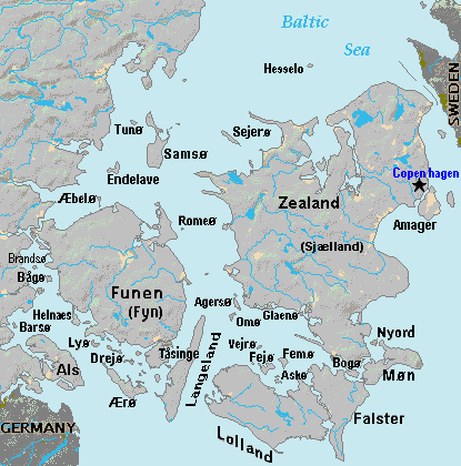
| Descrición | Terrain map of southeast Denmark, showing the major islands labeled, in the region between Germany and Sweden. The terrain data was extracted from the Demis map (on Wikimedia Commons) Image:La2-demis-denmark.png, and the extracted map was color-shifted to grayshade land areas (from the green Demis map). Labels are in font face Arial or Arial Narrow, sizes 8-10. |
| Data | |
| Orixe | Derivative of Demis map: Image:La2-demis-denmark.png |
| Autoría | Wikid77 (derivative of Demis map) |
Licenza
This image is in the public domain because it came from the site https://www.demis.nl/products/web-map-server/examples/ and was released by the copyright holder. Permission is granted to copy, distribute and/or modify this map since it is based on free of copyright images from: www.demis.nl. See also approval email on de.wp and its clarification.
|
| Esta obra foi colocada em domínio público pelo detentor dos direitos autorais, www.demis.nl. Isto se aplica em todo o mundo. Nalgúns países, isto pode non ser legalmente posible; entón: www.demis.nl concede a calquera o dereito de empregar esta obra para o propósito que considere oportuno, sen condicións, agás aquelas que sexan requiridas pola lei.
|
Historial do ficheiro
Prema nunha data/hora para ver o ficheiro tal e como estaba nese momento.
| Data/Hora | Miniatura | Dimensións | Usuario | Comentario | |
|---|---|---|---|---|---|
| actual | 3 de setembro de 2007 ás 18:51 | | 415 × 420 (23 kB) | Wikid77 | added 14 island names |
| 2 de setembro de 2007 ás 10:50 |  | 415 × 420 (22 kB) | Wikid77 | added "Sejero" + "Amager" | |
| 1 de setembro de 2007 ás 12:56 |  | 415 × 420 (22 kB) | Wikid77 | cut height 10px for square/undistorted resizing; cut banner "DENMARK" to appear in banner version | |
| 1 de setembro de 2007 ás 12:46 |  | 415 × 430 (22 kB) | Wikid77 | cut map width 10px as 415px magnified 3%; banner "DENMARK"; enlarged names; darkened Germany/Sweden | |
| 31 de agosto de 2007 ás 13:36 |  | 425 × 430 (22 kB) | Wikid77 | Terrain map of southeast Denmark, showing the major islands labeled, in the region between Germany and Sweden. The terrain data was extracted from the Demis map (on Wikimedia Commons) Image:La2-demis-denmark.png , and the extracted map w |
Uso do ficheiro
A seguinte páxina usa este ficheiro:
Uso global do ficheiro
Os seguintes wikis empregan esta imaxe:
- Uso en da.wikipedia.org
- Uso en el.wikipedia.org
- Uso en en.wikipedia.org
- Uso en es.wikipedia.org
- Uso en fi.wikipedia.org
- Uso en fr.wikipedia.org
- Uso en hr.wikipedia.org
- Uso en it.wikipedia.org
- Uso en ka.wikipedia.org
- Uso en la.wikipedia.org
- Uso en lt.wikipedia.org
- Uso en pt.wikipedia.org
- Uso en sl.wikipedia.org
- Uso en vi.wikipedia.org
- Uso en zh.wikipedia.org