Ficheiro:Map Denmark CIA extended.gif
Non se pode ver nunha resolución meirande.
Map_Denmark_CIA_extended.gif (300 × 347 píxeles; tamaño do ficheiro: 16 kB; tipo MIME: image/gif)
| Este ficheiro procede de Wikimedia Commons. A continuación móstrase a información da súa páxina de descrición. Commons é un repositorio libre de ficheiros multimedia. Pode contribuír alí cargando as súas imaxes. |
Resumo
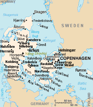
| Descrición | Map of Denmark, showing largest cities and island/region names. Most city names (31) have been labeled with font-face Arial or Arial Narrow, as font-size 8 or 10; the island/region names are labeled on the diagonal at a 20-degree slant. Denmark contains over 300 towns, but they are evenly dispersed around 35 main towns, except near Copenhagen, which has very high density. |
| Data | |
| Orixe | Derivative of CIA map (Wikimedia Commons): Image:Denmark-CIA WFB Map.png (adding 25 labels, restoring color to CIA hues, and magnified 15%) |
| Autoría | Wikid77 (derivative of CIA map, adding 25 labels) |
| Outras versións |
This map has some variations:
|
Licenza
Esta imaxe atópase no dominio público, xa que o seu contido provén do World Factbook, unha publicación da Axencia Central de Intelixencia (CIA) dos Estados Unidos da América.
|
 |
Format

This file is purposely maintained in GIF format (most international GIF-related patents have expired) for compatibility with the original CIA maps. Semi-automatic conversions to PNG-format might lose the color hues of the CIA maps, tending to shift to lighter blue and shift beige to white. A larger, detailed version of the map is being expanded, with more of the smaller 300 towns added.
Historial do ficheiro
Prema nunha data/hora para ver o ficheiro tal e como estaba nese momento.
| Data/Hora | Miniatura | Dimensións | Usuario | Comentario | |
|---|---|---|---|---|---|
| actual | 30 de novembro de 2012 ás 16:26 | | 300 × 347 (16 kB) | Ras67 | cropped |
| 4 de setembro de 2007 ás 13:51 |  | 300 × 350 (16 kB) | Wikid77 | relabeled "NORWAY"/"POLAND"; raised "Taastrup"/"Koge" near city-dots | |
| 3 de setembro de 2007 ás 15:41 |  | 300 × 350 (16 kB) | Wikid77 | added "Kalundborg" by lowering "Fredericia"/"Odense"/"Fyn" and lowered Copenhagen star, "Taastrup"/"Koge" and "Greve Strand" etc. | |
| 31 de agosto de 2007 ás 13:24 |  | 300 × 350 (16 kB) | Wikid77 | slashed 'o' 3x | |
| 29 de agosto de 2007 ás 06:04 |  | 300 × 350 (16 kB) | Wikid77 | {{Information | Description=Map of Denmark, showing largest cities and island/region names. | Source=Derivative of CIA map | Date=29-August-2007 | Author= Wikid77 (derivative of CIA map) | Permission=(see below) }} |
Uso do ficheiro
A seguinte páxina usa este ficheiro:
Uso global do ficheiro
Os seguintes wikis empregan esta imaxe:
- Uso en ast.wikipedia.org
- Uso en ca.wikipedia.org
- Uso en es.wikipedia.org
- Uso en et.wikipedia.org
- Uso en fa.wikipedia.org
- Uso en hr.wikipedia.org
- Uso en ja.wikipedia.org
- Uso en kn.wikipedia.org
- Uso en ko.wikipedia.org
- Uso en mk.wikipedia.org
- Uso en ms.wikipedia.org
- Uso en pt.wikipedia.org
- Uso en th.wikipedia.org
- Uso en vi.wikipedia.org
- Uso en zh.wikipedia.org