Ficheiro:Lancashire UK locator map 2010.svg

Tamaño desta vista previa en PNG do ficheiro en formato SVG: 494 × 600 píxeles. Outras resolucións: 198 × 240 píxeles | 395 × 480 píxeles | 633 × 768 píxeles | 843 × 1.024 píxeles | 1.687 × 2.048 píxeles | 1.108 × 1.345 píxeles.
Ficheiro orixinal (ficheiro SVG; resolución de 1.108 × 1.345 píxeles; tamaño do ficheiro: 302 kB)
| Este ficheiro procede de Wikimedia Commons. A continuación móstrase a información da súa páxina de descrición. Commons é un repositorio libre de ficheiros multimedia. Pode contribuír alí cargando as súas imaxes. |
Юююююю .
Че
Resumo
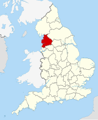
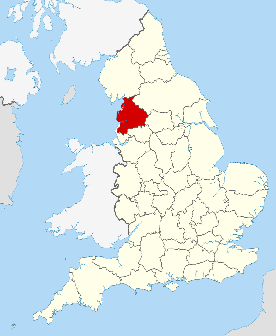
| Descrición | Location of the ceremonial county of Lancashire within England. |
| Data | |
| Orixe |
National Geospatial-Intelligence Agency
|
| Autoría | Nilfanion |
Licenza
Eu, como posuidor dos dereitos de autor desta obra, pola presente publícoa baixo as seguintes licenzas:
Este ficheiro está licenciado baixo a licenza Creative Commons recoñecemento compartir igual 3.0 sen adaptar.
- Vostede é libre de:
- compartir – copiar, distribuír e difundir a obra
- facer obras derivadas – adaptar a obra
- Baixo as seguintes condicións:
- recoñecemento – Debe indicar a debida atribución de autoría, fornecer unha ligazón á licenza e indicar se se realizaron cambios. Pode facer isto de calquera forma razoable, mais non nunha forma que indique que quen posúe a licenza apoia ou subscribe o seu uso da obra.
- compartir igual – Se altera, transforma ou amplía este contido, debe publicar as súas contribucións baixo a mesma licenza ou outra compatible á orixinal.

|
Autorízase a copia, distribución e/ou modificación deste documento baixo os termos da licenza de documentación libre GNU, versión 1.2 ou calquera outra que posteriormente publique a Free Software Foundation; sen seccións invariables, textos de portada, nin textos de contraportada. Inclúese unha copia da devandita licenza na sección titulada GNU Free Documentation License. |
Pode seleccionar a licenza que desexe.

|
This is one of the images forming part of the Valued image set: Locator maps of the Ceremonial counties of England on Wikimedia Commons. The image set has been assessed under the valued image set criteria and is considered the most valued set on Commons within the scope:
Locator maps of the Ceremonial counties of England
You can see its nomination at Commons:Valued image candidates/Locator maps of English ceremonial counties. |
Historial do ficheiro
Prema nunha data/hora para ver o ficheiro tal e como estaba nese momento.
| Data/Hora | Miniatura | Dimensións | Usuario | Comentario | |
|---|---|---|---|---|---|
| actual | 23 de novembro de 2010 ás 22:39 | | 1.108 × 1.345 (302 kB) | Nilfanion | == Summary == {{Information |Description=Location of the ceremonial county of Lancashire within England. |Source=Ordnance Survey [https://www.ordnancesurvey.co.uk/opendatadownload/products.html OpenData]: *County bou |
Uso do ficheiro
A seguinte páxina usa este ficheiro:
Uso global do ficheiro
Os seguintes wikis empregan esta imaxe:
- Uso en af.wikipedia.org
- Uso en ar.wikipedia.org
- Uso en ast.wikipedia.org
- Uso en az.wikipedia.org
- Uso en be-tarask.wikipedia.org
- Uso en be.wikipedia.org
- Uso en bg.wikipedia.org
- Uso en br.wikipedia.org
- Uso en ca.wikipedia.org
- Uso en ceb.wikipedia.org
- Uso en cs.wikipedia.org
- Uso en en.wikipedia.org
- Lancashire
- National nature reserves in Lancashire
- Grit Fell
- Wolfhole Crag
- Fair Snape Fell
- Leyland Hundred
- Lonsdale Hundred
- Bleasdale
- Knott End-on-Sea
- Great Altcar
- Trawden
- White Hill (Forest of Bowland)
- Hawthornthwaite Fell
- Gambleside
- Brownhill
- Catforth
- Over Wyre
- Oakenshaw, Lancashire
- Langho
- River Tawd
- Downholland Cross
- Haskayne
- Farington
- Salwick
- Barrow Nook
- Foulridge
- Wennington, Lancashire
- Template:Lancashire-geo-stub
- Eagland Hill
- Yarrow Valley Country Park
- Quernmore
- Central Lancashire
- Whittington, Lancashire
- River Hyndburn
- Barley-with-Wheatley Booth
- Barnacre-with-Bonds
- Bickerstaffe
- Municipal Borough of Morecambe and Heysham
Ollar o uso global deste ficheiro.