Ficheiro:Kiplingsindia.jpg

Ficheiro orixinal (802 × 663 píxeles; tamaño do ficheiro: 114 kB; tipo MIME: image/jpeg)
| Este ficheiro procede de Wikimedia Commons. A continuación móstrase a información da súa páxina de descrición. Commons é un repositorio libre de ficheiros multimedia. Pode contribuír alí cargando as súas imaxes. |
Resumo
| Descrición |
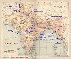
ResumoThis is a low-resolution (40% of original) scanned image of the map, "Politial Divisions of the Indian Empire" from the Imperial Gazeteer of India (volume 26, Atlas), published by the Oxford University Press, 1909. The map image was scanned and then annotated by me (Sanjay Tiwari 18:24, 30 September 2006 (UTC)) |
||||||
| Orixe | Obra propia | ||||||
| Autoría | User Sanjay Tiwari on en.wikipedia | ||||||
| Licenza (Reuso deste ficheiro) |
|
||||||
| Outras versións |
Originally from en.wikipedia; description page is (was) here * 18:24, 30 September 2006 [[:en:User:Sanjay Tiwari|Sanjay Tiwari]] 880×680 (126,459 bytes) <span class="comment">(This is a low-resolution (40% of original) scanned image of the map, "Politial Divisions of the Indian Empire" from the ''Imperial Gazeteer of India'' (volume 26, Atlas), published by the Oxford University Press, 1909. The map image was scanned and the)</span> |
||||||
(Uploaded using CommonsHelper or PushForCommons)
Licenza
|
Este material está no dominio público nos demais países onde os dereitos de autor se estenden por 70 anos (ou menos) trala morte do autor.
| |
| Este ficheiro foi identificado como libre de restricións baixo as leis de dereitos de autor, incluídos todos os dereitos relacionados. | |
Rexistro de cargas orixinal
- 2007-05-14 07:25 Kintetsubuffalo 802×663× (117058 bytes) trimmed to make edges equal
- 2006-09-30 18:24 Sanjay Tiwari 880×680× (126459 bytes) This is a low-resolution (40% of original) scanned image of the map, "Politial Divisions of the Indian Empire" from the ''Imperial Gazeteer of India'' (volume 26, Atlas), published by the Oxford University Press, 1909. The map image was scanned and the
Historial do ficheiro
Prema nunha data/hora para ver o ficheiro tal e como estaba nese momento.
| Data/Hora | Miniatura | Dimensións | Usuario | Comentario | |
|---|---|---|---|---|---|
| actual | 28 de marzo de 2016 ás 13:39 | | 802 × 663 (114 kB) | OgreBot | (BOT): Uploading old version of file from en.wikipedia; originally uploaded on 2007-05-14 07:25:05 by Kintetsubuffalo |
| 28 de marzo de 2016 ás 13:39 |  | 880 × 680 (123 kB) | OgreBot | (BOT): Uploading old version of file from en.wikipedia; originally uploaded on 2006-09-30 18:24:12 by Sanjay Tiwari | |
| 13 de novembro de 2006 ás 20:17 |  | 776 × 600 (95 kB) | Chechof | {{Information| |Description= == Summary == This is a low-resolution (40% of original) scanned image of the map, "Politial Divisions of the Indian Empire" from the ''Imperial Gazeteer of India'' (volume 26, Atlas), published by the Oxford University Press |
Uso do ficheiro
A seguinte páxina usa este ficheiro:
Uso global do ficheiro
Os seguintes wikis empregan esta imaxe:
- Uso en ca.wikipedia.org
- Uso en el.wikipedia.org
- Uso en en.wikipedia.org
- Uso en es.wikipedia.org
- Uso en hi.wikipedia.org
- Uso en hu.wikipedia.org
- Uso en ja.wikipedia.org
- Uso en pt.wikipedia.org
- Uso en tt.wikipedia.org
- Uso en vi.wikipedia.org