Ficheiro:Island of Ireland location map Clare.svg

Tamaño desta vista previa en PNG do ficheiro en formato SVG: 481 × 599 píxeles. Outras resolucións: 192 × 240 píxeles | 385 × 480 píxeles | 616 × 768 píxeles | 822 × 1.024 píxeles | 1.643 × 2.048 píxeles | 1.450 × 1.807 píxeles.
Ficheiro orixinal (ficheiro SVG; resolución de 1.450 × 1.807 píxeles; tamaño do ficheiro: 642 kB)
| Este ficheiro procede de Wikimedia Commons. A continuación móstrase a información da súa páxina de descrición. Commons é un repositorio libre de ficheiros multimedia. Pode contribuír alí cargando as súas imaxes. |
| Descrición |
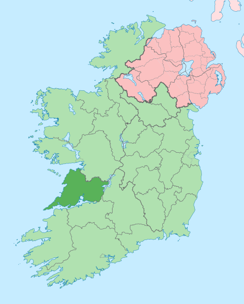
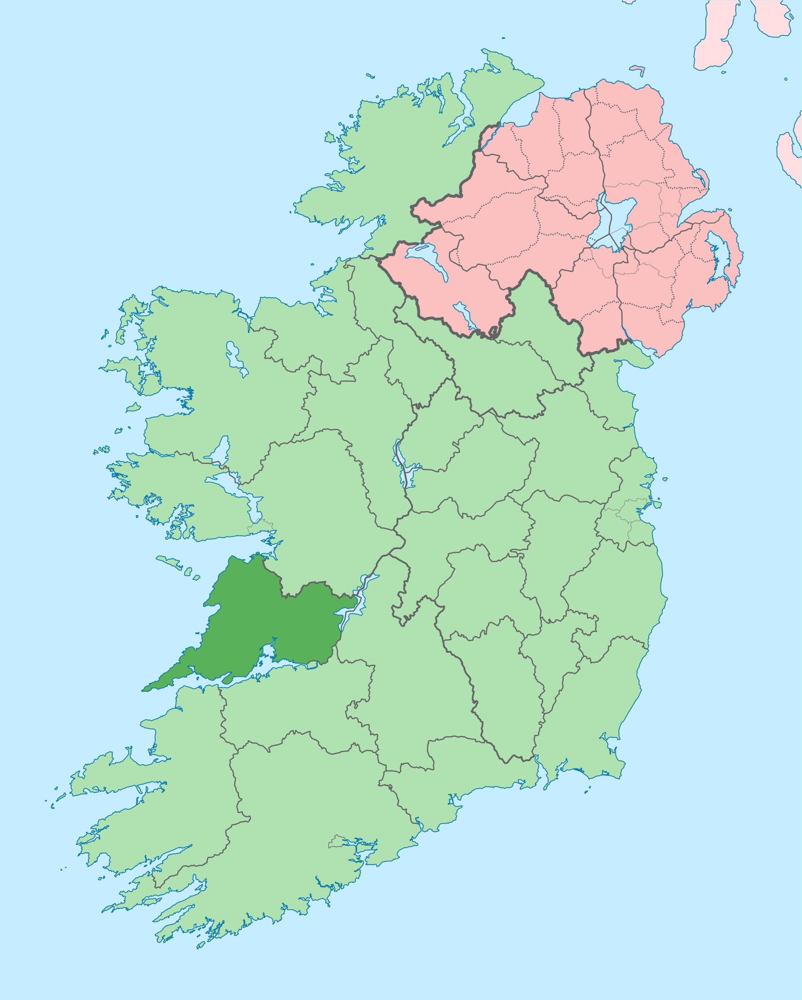
English: The island of Ireland, showing international border between Ireland and Northern Ireland, traditional provinces, traditional counties, and local authority areas in Ireland and Northern Ireland. |
| Data | (UTC) |
| Orixe | |
| Autoría |
|
| Esta é unha imaxe retocada,en o que significa que a súa versión orixinal foi alterada dixitalmente. Modificacións: Coloured in regions with county of article highlighted. A orixinal pódese ver aquí: Island of Ireland location map.svg. As modificacións realizounas Mabuska.
|
Eu, como posuidor dos dereitos de autor desta obra, pola presente publícoa baixo a seguinte licenza:
Este ficheiro está licenciado baixo a licenza Creative Commons recoñecemento compartir igual 3.0 sen adaptar.
- Vostede é libre de:
- compartir – copiar, distribuír e difundir a obra
- facer obras derivadas – adaptar a obra
- Baixo as seguintes condicións:
- recoñecemento – Debe indicar a debida atribución de autoría, fornecer unha ligazón á licenza e indicar se se realizaron cambios. Pode facer isto de calquera forma razoable, mais non nunha forma que indique que quen posúe a licenza apoia ou subscribe o seu uso da obra.
- compartir igual – Se altera, transforma ou amplía este contido, debe publicar as súas contribucións baixo a mesma licenza ou outra compatible á orixinal.
Rexistro de cargas orixinal
This image is a derivative work of the following images:
- File:Island_of_Ireland_location_map.svg licensed with Cc-by-sa-3.0
- 2010-03-06T20:43:33Z Rannpháirtí anaithnid 1450x1807 (679207 Bytes) Fix incorrectly coloured isands.
- 2010-03-03T22:19:29Z Rannpháirtí anaithnid 1450x1807 (679744 Bytes) {{Information |Description={{de|Positionskarte von [[:de:Irland|Irland]]}} Quadratische Plattkarte, N-S-Streckung 170 %. Geographische Begrenzung der Karte: * N: 55.6° N * S: 51.2° N * W: 11.0° W * O: 5.0° W {{en|Location
Carregada com derivativeFX
Historial do ficheiro
Prema nunha data/hora para ver o ficheiro tal e como estaba nese momento.
| Data/Hora | Miniatura | Dimensións | Usuario | Comentario | |
|---|---|---|---|---|---|
| actual | 28 de xuño de 2020 ás 14:05 | | 1.450 × 1.807 (642 kB) | Chipmunkdavis | Colouring in Aughinish |
| 26 de xuño de 2020 ás 15:54 |  | 1.450 × 1.807 (642 kB) | Chipmunkdavis | Rmv stray number in code | |
| 26 de xuño de 2020 ás 15:26 |  | 1.450 × 1.807 (642 kB) | Chipmunkdavis | Merging Tipperary and Waterford shapes | |
| 26 de xuño de 2020 ás 12:55 |  | 1.450 × 1.807 (643 kB) | Chipmunkdavis | Removing Limerick City | |
| 25 de xuño de 2020 ás 16:21 |  | 1.450 × 1.807 (643 kB) | Chipmunkdavis | Per the Local Government Reform Act 2014, removing the Tipperary border and the Waterford City border. | |
| 25 de xuño de 2020 ás 16:10 |  | 1.450 × 1.807 (646 kB) | Chipmunkdavis | Removing lots of stray objects. Fixing location of Clare and one island slightly. | |
| 25 de xuño de 2020 ás 15:45 |  | 1.450 × 1.807 (695 kB) | Chipmunkdavis | Colour islands in, place all islands and borders in groups, remove some blank and redundant shapes | |
| 19 de xullo de 2010 ás 00:41 |  | 1.450 × 1.807 (815 kB) | Mabuska | {{Information |Description={{en|The island of Ireland, showing international border between Northern Ireland and Republic of Ireland, traditional provinces, traditional counties, and local authority areas in the Republic of Ireland and Northern Ireland.}} |
Uso do ficheiro
As seguintes 9 páxinas usan este ficheiro:
Uso global do ficheiro
Os seguintes wikis empregan esta imaxe:
- Uso en ar.wikipedia.org
- Uso en ast.wikipedia.org
- Uso en bg.wikipedia.org
- Uso en ca.wikipedia.org
- Uso en ceb.wikipedia.org
- Uso en cs.wikipedia.org
- Uso en en.wikipedia.org
- County Clare
- Inagh
- Ennis
- List of Ireland-related topics
- Shannon, County Clare
- Lissycasey
- Shannon Free Zone
- Lisdoonvarna
- Cratloe
- Doolin
- Kilfenora
- Ballyvaughan
- Carran
- Kilkee
- Kilrush
- Clarecastle
- Ennistymon
- Killaloe, County Clare
- Lahinch
- Liscannor
- Mountshannon
- Newmarket-on-Fergus
- O'Brien's Bridge
- Spanish Point, County Clare
- Aughinish, County Clare
Ollar o uso global deste ficheiro.