Ficheiro:Hercynides EN.svg

Tamaño desta vista previa en PNG do ficheiro en formato SVG: 550 × 370 píxeles. Outras resolucións: 320 × 215 píxeles | 640 × 431 píxeles | 1.024 × 689 píxeles | 1.280 × 861 píxeles | 2.560 × 1.722 píxeles.
Ficheiro orixinal (ficheiro SVG; resolución de 550 × 370 píxeles; tamaño do ficheiro: 108 kB)
| Este ficheiro procede de Wikimedia Commons. A continuación móstrase a información da súa páxina de descrición. Commons é un repositorio libre de ficheiros multimedia. Pode contribuír alí cargando as súas imaxes. |
Resumo
| Descrición |
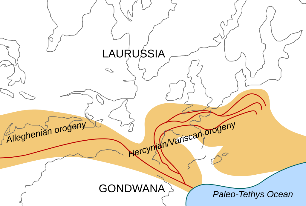
English: Location of the Hercynian/Variscan/Alleghanian mountain chains in the middle of the Carboniferous period. Present day coastlines are shown for reference. Red lines are sutures, capitalized names are the different continents that joined during these orogenies.
Literature used to make this map:
|
| Data | |
| Orixe | Obra propia |
| Autoría | Woudloper |
| Outras versións |
Obras derivadas deste ficheiro: Image:Hercynides NL.svg, Image:Hercynides DE.svg, Image:Hercynides IT.svg |

|
Este ficheiro SVG emprega texto encapsulado que pode ser traducido doadamente a calquera lingua usando un editor SVG como Inkscape ou Adobe Illustrator. Vexa máis información. Tamén pode descargalo e traducilo manualmente empregando un editor de texto. |
Licenza
Este ficheiro está licenciado baixo a licenza Creative Commons recoñecemento compartir igual xenérico 1.0.
- Vostede é libre de:
- compartir – copiar, distribuír e difundir a obra
- facer obras derivadas – adaptar a obra
- Baixo as seguintes condicións:
- recoñecemento – Debe indicar a debida atribución de autoría, fornecer unha ligazón á licenza e indicar se se realizaron cambios. Pode facer isto de calquera forma razoable, mais non nunha forma que indique que quen posúe a licenza apoia ou subscribe o seu uso da obra.
- compartir igual – If you alter, transform, or build upon this work, you must distribute the resulting work under the same license as the original.
Historial do ficheiro
Prema nunha data/hora para ver o ficheiro tal e como estaba nese momento.
| Data/Hora | Miniatura | Dimensións | Usuario | Comentario | |
|---|---|---|---|---|---|
| actual | 2 de decembro de 2008 ás 19:29 | | 550 × 370 (108 kB) | Woudloper | {{Information |Description={{en|1=Location of the Hercynian/Variscan/Alleghanian mountain chains in the middle of the Carboniferous period. Present day coastlines are shown for reference. Red lines are sutures, capitalized names are the different continen |
Uso do ficheiro
As seguintes 2 páxinas usan este ficheiro:
Uso global do ficheiro
Os seguintes wikis empregan esta imaxe:
- Uso en ca.wikipedia.org
- Uso en en.wikipedia.org
- Uso en fa.wikipedia.org
- Uso en fr.wikipedia.org
- Uso en nn.wikipedia.org
- Uso en pl.wikipedia.org
- Uso en ro.wikipedia.org
- Uso en tr.wikipedia.org
- Uso en zh.wikipedia.org