Ficheiro:Han dynasty Kingdoms 195 BC.png
Tamaño desta vista previa: 530 × 599 píxeles. Outras resolucións: 212 × 240 píxeles | 424 × 480 píxeles | 679 × 768 píxeles | 905 × 1.024 píxeles | 1.483 × 1.677 píxeles.
Ficheiro orixinal (1.483 × 1.677 píxeles; tamaño do ficheiro: 736 kB; tipo MIME: image/png)
| Este ficheiro procede de Wikimedia Commons. A continuación móstrase a información da súa páxina de descrición. Commons é un repositorio libre de ficheiros multimedia. Pode contribuír alí cargando as súas imaxes. |
Resumo
| Descrición |
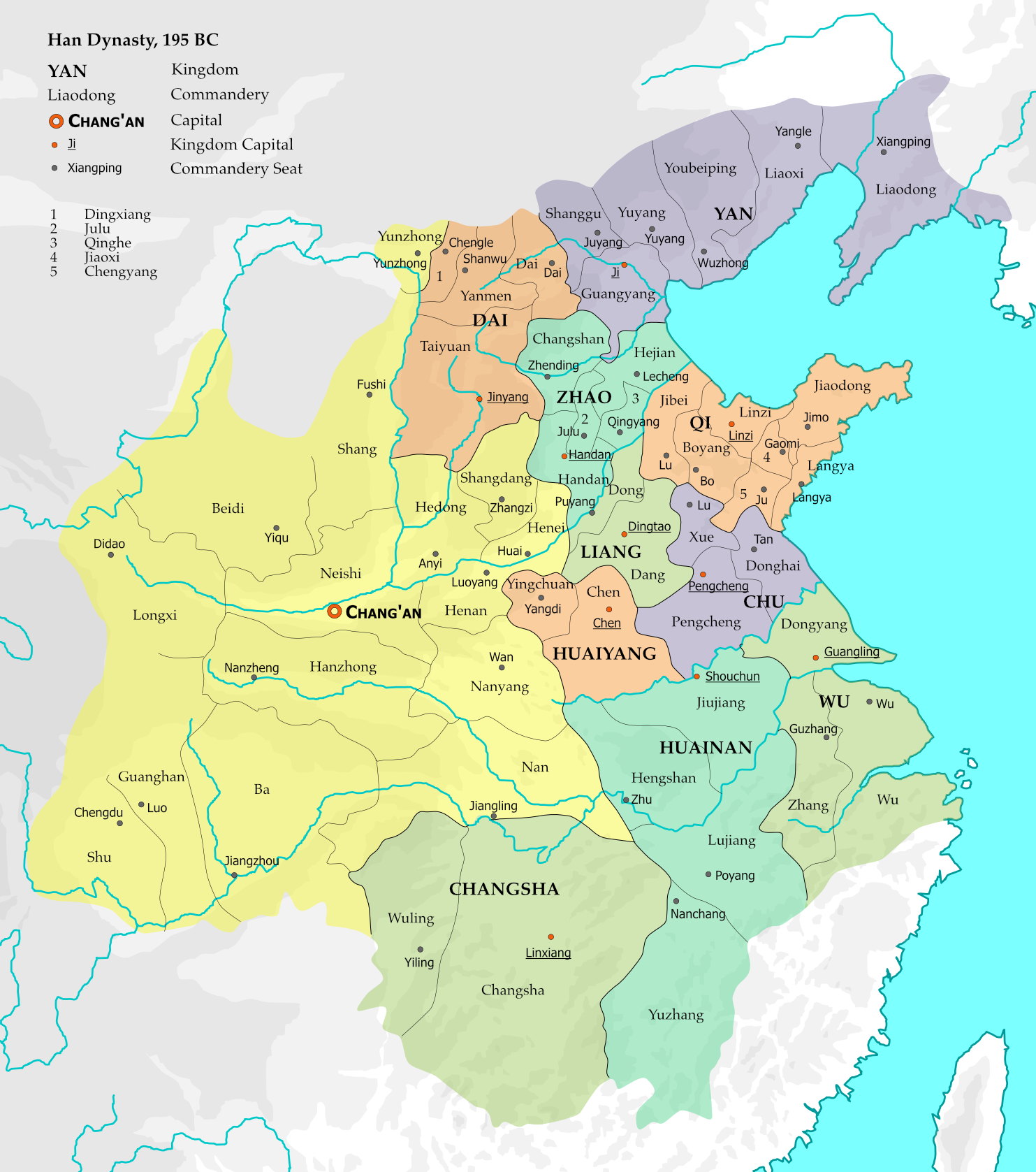
English: The map represents the situation of Western Han dynasty in the 12th year of Emperor Gao (195 BC). 10 kingdoms existed within the Han empire at the time, and with the exception of Changsha, all are headed by members of the imperial family. 15 commanderies in the central and western parts of the empire were directly administered by the imperial government.
The borders are based on Zhou Zhenhe's Xihan Zhengqu Dili (西汉政区地理, "Administrative Geography of Western Han"), 1987.
This file is the png version of File:Han dynasty Kingdoms 195 BC.svg. |
| Data | |
| Orixe |
Obra própria, usando:
|
| Autoría | Esiymbro |
| Outras versións |
[]
|


Licenza
Eu, como posuidor dos dereitos de autor desta obra, pola presente publícoa baixo a seguinte licenza:
Este ficheiro está licenciado baixo a licenza Creative Commons recoñecemento compartir igual 4.0 internacional.
- Vostede é libre de:
- compartir – copiar, distribuír e difundir a obra
- facer obras derivadas – adaptar a obra
- Baixo as seguintes condicións:
- recoñecemento – Debe indicar a debida atribución de autoría, fornecer unha ligazón á licenza e indicar se se realizaron cambios. Pode facer isto de calquera forma razoable, mais non nunha forma que indique que quen posúe a licenza apoia ou subscribe o seu uso da obra.
- compartir igual – Se altera, transforma ou amplía este contido, debe publicar as súas contribucións baixo a mesma licenza ou outra compatible á orixinal.
Historial do ficheiro
Prema nunha data/hora para ver o ficheiro tal e como estaba nese momento.
| Data/Hora | Miniatura | Dimensións | Usuario | Comentario | |
|---|---|---|---|---|---|
| actual | 10 de novembro de 2019 ás 14:42 | | 1.483 × 1.677 (736 kB) | Esiymbro | User created page with UploadWizard |
Uso do ficheiro
A seguinte páxina usa este ficheiro:
Uso global do ficheiro
Os seguintes wikis empregan esta imaxe:
- Uso en ckb.wikipedia.org
- Uso en en.wikipedia.org
- Uso en es.wikipedia.org
- Uso en fa.wikipedia.org
- Uso en id.wikipedia.org
- Uso en mt.wikipedia.org
- Uso en my.wikipedia.org
- Uso en pl.wikipedia.org
- Uso en si.wikipedia.org
- Uso en sl.wikipedia.org
- Uso en vi.wikipedia.org