Ficheiro:GulfofMaine.jpg
Non se pode ver nunha resolución meirande.
GulfofMaine.jpg (523 × 544 píxeles; tamaño do ficheiro: 285 kB; tipo MIME: image/jpeg)
| Este ficheiro procede de Wikimedia Commons. A continuación móstrase a información da súa páxina de descrición. Commons é un repositorio libre de ficheiros multimedia. Pode contribuír alí cargando as súas imaxes. |
Origin
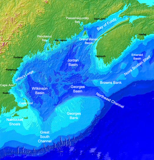
Found on the english Wikipedia Image :GulfofMaine.jpg. Digital bathymetry map of the Gulf of Maine. Credit: National Oceanographic and Atmospheric Administration and U.S. Geological Survey (USGS) Woods Hole, MA Labels by Syagria.)
Resumo
Digital bathymetry map of the Gulf of Maine. Credit: National Oceanographic and Atmospheric Administration and U.S. Geological Survey (USGS) Woods Hole, MA. Labels by Syagria.
Licenza
Esta imagem está em domínio público pois ela contém material que vieram originalmente da National Oceanic and Atmospheric Administration dos EUA, tirada ou feita durante o trajeto de um funcionário em obrigações oficiais.
|
Historial do ficheiro
Prema nunha data/hora para ver o ficheiro tal e como estaba nese momento.
| Data/Hora | Miniatura | Dimensións | Usuario | Comentario | |
|---|---|---|---|---|---|
| actual | 27 de novembro de 2006 ás 00:32 | | 523 × 544 (285 kB) | TCY | ==Origin== Found on the english Wikipedia [http://en.wikipedia.org/wiki/Image:GulfofMaine.jpg Image :GulfofMaine.jpg] == Summary == Digital bathymetry map of the Gulf of Maine. Credit: National Oceanographic and Atmospheric Administration and U.S. Geolog |
Uso do ficheiro
A seguinte páxina usa este ficheiro:
Uso global do ficheiro
Os seguintes wikis empregan esta imaxe:
- Uso en az.wikipedia.org
- Uso en be.wikipedia.org
- Uso en bg.wikipedia.org
- Uso en ca.wikipedia.org
- Uso en ce.wikipedia.org
- Uso en da.wikipedia.org
- Uso en en.wikipedia.org
- Uso en en.wikiversity.org
- Uso en es.wikipedia.org
- Uso en eu.wikipedia.org
- Uso en fa.wikipedia.org
- Uso en fi.wikipedia.org
- Uso en fr.wikipedia.org
- Uso en hr.wikipedia.org
- Uso en id.wikipedia.org
- Uso en is.wikipedia.org
- Uso en ka.wikipedia.org
- Uso en ko.wikipedia.org
- Uso en lt.wikipedia.org
- Uso en ml.wikipedia.org
- Uso en pt.wikipedia.org
- Uso en ru.wikipedia.org
- Uso en ta.wikipedia.org
- Uso en zh.wikipedia.org