Ficheiro:Earth dry elevation.stl
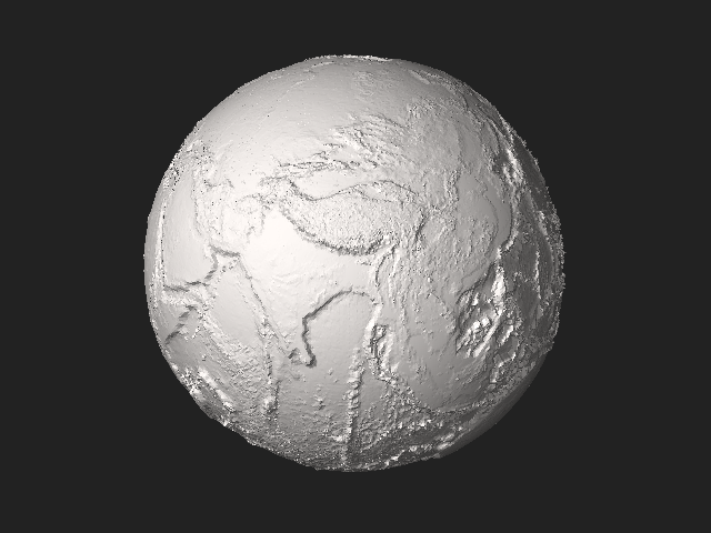
Tamaño desta vista previa en PNG do ficheiro en formato STL: 800 × 600 píxeles. Outras resolucións: 320 × 240 píxeles | 640 × 480 píxeles | 1.024 × 768 píxeles | 1.280 × 960 píxeles | 2.560 × 1.920 píxeles | 5.120 × 3.840 píxeles.
Ficheiro orixinal (5.120 × 2.880 píxeles; tamaño do ficheiro: 27,66 MB; tipo MIME: application/sla)
| Este ficheiro procede de Wikimedia Commons. A continuación móstrase a información da súa páxina de descrición. Commons é un repositorio libre de ficheiros multimedia. Pode contribuír alí cargando as súas imaxes. |
View Earth dry elevation.stl on viewstl.com
Resumo
| Descrición |
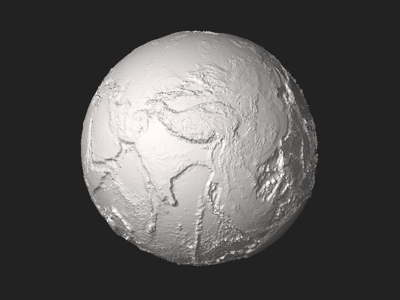
English: Earth without liquid water greatly exaggerated elevation model by CMG Lee using depthmap File:Earth_dry_elevation.png generated from NASA Visible Earth topography and bathymetry data. |
|||
| Data | ||||
| Orixe | Obra propia | |||
| Autoría | Cmglee | |||
| Outras versións |
|


Python source
#!/usr/bin/env python

exaggeration   = 10
header         = ('Dry Earth %s-times-exaggerated elevation model by CMG Lee using NASA data.'
                  % (exaggeration))
path_png_alt   = 'earth_dry_elevation.png' ## 1-channel equirectangular PNG
luma_datum     = 141                       ## image intensity level (of 0-255) of datum
radius_datum   = 6378.137                  ## mean radius of zero level in km
f_wgs84        = 1 / 298.257223563         ## WGS84 flattening factor
km_per_luma    = (10.994 + 8.848) / 255 * exaggeration ## min and max elevations in km
scale          = 1e-2                      ## overall scale of model in km^-1
lat_offset     = 5.0 / 8                   ## rotation around planet axis in revolutions
n_division     = 200                       ## each cubic face divided into n_division^2 squares

class Png:
 def __init__(self, path):
  (self.width, self.height, self.pixels, self.metadatas) = png.Reader(path).read_flat()
 def __str__(self): return str((self.width, self.height, len(self.pixels), self.metadatas))

import time, re, math, struct, png
time.start = time.time()
def log(string): print('%6.3fs\t%s' % (time.time() - time.start, string))
def fmt(string): ## string.format(**vars()) using tags {expression!format} by CMG Lee
 def f(tag): i_sep = tag.rfind('!'); return (re.sub('\.0+$', '', str(eval(tag[1:-1])))
  if (i_sep < 0) else ('{:%s}' % tag[i_sep + 1:-1]).format(eval(tag[1:i_sep])))
 return (re.sub(r'(?<!{){[^{}]+}', lambda m:f(m.group()), string)
         .replace('{{', '{').replace('}}', '}'))
def append(obj, string): return obj.append(fmt(string))
def tabbify(cellss, separator='|'):
 cellpadss = [list(rows) + [''] * (len(max(cellss, key=len)) - len(rows)) for rows in cellss]
 fmts = ['%%%ds' % (max([len(str(cell)) for cell in cols])) for cols in zip(*cellpadss)]
 return '\n'.join([separator.join(fmts) % tuple(rows) for rows in cellpadss])
def hex_rgb(colour): ## convert [#]RGB to #RRGGBB and [#]RRGGBB to #RRGGBB
 return '#%s' % (colour if len(colour) > 4 else ''.join([c * 2 for c in colour])).lstrip('#')
def viscam_colour(colour):
 colour_hex      = hex_rgb(colour)
 colour_top5bits = [int(colour_hex[i:i+2], 16) >> 3 for i in range(1,7,2)]
 return (1 << 15) + (colour_top5bits[0] << 10) + (colour_top5bits[1] << 5) + colour_top5bits[2]
def roundm(x, multiple=1):
 if   (isinstance(x, tuple)): return tuple(roundm(list(x), multiple))
 elif (isinstance(x, list )): return [roundm(x_i, multiple) for x_i in x]
 else: return int(math.floor(float(x) / multiple + 0.5)) * multiple
def average(xs): return None if (len(xs) == 0) else float(sum(xs)) / len(xs)
def flatten(lss): return [l for ls in lss for l in ls]
def rotate(facetss, degs): ## around x then y then z axes
 (deg_x,deg_y,deg_z) = degs
 (sin_x,cos_x) = (math.sin(math.radians(deg_x)), math.cos(math.radians(deg_x)))
 (sin_y,cos_y) = (math.sin(math.radians(deg_y)), math.cos(math.radians(deg_y)))
 (sin_z,cos_z) = (math.sin(math.radians(deg_z)), math.cos(math.radians(deg_z)))
 facet_rotatess = []
 for facets in facetss:
  facet_rotates = []
  for i_point in range(4):
   (x,y,z) = [facets[3 * i_point + i_xyz] for i_xyz in range(3)]
   if (x is None or y is None or z is None): facet_rotates += [x,y,z]

   else:
    (y,z) = (y * cos_x - z * sin_x, y * sin_x + z * cos_x) ## rotate about x
    (x,z) = (x * cos_y + z * sin_y,-x * sin_y + z * cos_y) ## rotate about y
    (x,y) = (x * cos_z - y * sin_z, x * sin_z + y * cos_z) ## rotate about z
    facet_rotates += [round(value, 9) for value in [x,y,z]]
  facet_rotatess.append(facet_rotates)
 return facet_rotatess
def translate(facetss, ds): ## ds = (dx,dy,dz)
 return [facets[:3] + [facets[3 * i_point + i_xyz] + ds[i_xyz]
                       for i_point in range(1,4) for i_xyz in range(3)]  for facets in facetss]
def flip(facetss): return [facets[:3]+facets[6:9]+facets[3:6]+facets[9:] for facets in facetss]

def cube_xyz_to_sphere_xyz(cube_xyzs):
 (x,y,z)                         = [float(xyz) for xyz in cube_xyzs]
 (x_squared,y_squared,z_squared) = (x * x,y * y,z * z)
 return (x * (1 - (y_squared + z_squared) / 2 + y_squared * z_squared / 3) ** 0.5,
         y * (1 - (x_squared + z_squared) / 2 + x_squared * z_squared / 3) ** 0.5,
         z * (1 - (y_squared + x_squared) / 2 + y_squared * x_squared / 3) ** 0.5)
def xyz_to_lla(xyzs):
 (x,y,z) = xyzs
 alt     = (x * x + y * y + z * z) ** 0.5
 lon     = math.atan2(y, x)
 lat     = math.asin(z / alt)
 return (lat,lon,alt)
deg_90 = math.pi / 2
def find_alt(lat_lons, altss):
  (lat,lon) = lat_lons
  if   (lat ==  deg_90): alt = average(altss[ 0])
  elif (lat == -deg_90): alt = average(altss[-1])
  else:
   (width,height) = (len(altss[0]),len(altss))
   x              = (0.5 + lon / (deg_90 * 4) + lat_offset) * width
   y              = (0.5 - lat / (deg_90 * 2)             ) * height
   (x_int,y_int)  = (int(x)   , int(y)   )
   (x_dec,y_dec)  = (x - x_int, y - y_int)
   (x0,x1)        = (x_int % width , (x_int + 1) % width )
   (y0,y1)        = (y_int % height, (y_int + 1) % height)
   alt            = ((altss[y0][x0] * (1 - x_dec) + altss[y1][x0] * x_dec) * (1 - y_dec) +
                     (altss[y0][x1] * (1 - x_dec) + altss[y1][x1] * x_dec) *      y_dec)
  # print(map(math.degrees, lat_lons), y,x, alt)
  return alt
def radius_wgs84(lat):
 if (lat in radius_wgs84.cachess): return radius_wgs84.cachess[lat]
 (sin_lat, cos_lat)        = (math.sin(lat), math.cos(lat))
 ff                        = (1 - f_wgs84) ** 2
 c                         = 1 / (cos_lat ** 2 + ff * sin_lat ** 2) ** 0.5
 s                         = c * ff
 radius_c_s_s              = (radius_datum * c, radius_datum * s)
 radius_wgs84.cachess[lat] = radius_c_s_s
 return radius_c_s_s
radius_wgs84.cachess = {}
def lla_to_sphere_xyz(llas):
 (lat,lon,alt)        = llas
 (sin_lat,sin_lon)    = (math.sin(lat),math.sin(lon))
 (cos_lat,cos_lon)    = (math.cos(lat),math.cos(lon))
 (radius_c, radius_s) = [(c_s_radius + alt * km_per_luma) * scale
                         for c_s_radius in radius_wgs84(lat)]
 return (radius_c * cos_lat * cos_lon,radius_c * cos_lat * sin_lon,radius_s * sin_lat)
def xyz_alt_to_xyza(xyzs, altss):
 (lat,lon,alt) = xyz_to_lla(xyzs)
 alt           = find_alt((lat,lon), altss)
 lla_alts      = [list(lla_to_sphere_xyz((lat,lon,alt))), alt]
 return lla_alts

log("Read elevation data")
png_alt = Png(path_png_alt)
if (png_alt.metadatas['planes'] != 1): print("%s not 1-channel PNG" % (path_png_alt)); sys.exit(1)
log(png_alt)
altss = [[png_alt.pixels[png_alt.width * y + x] - luma_datum
          for x in range(png_alt.width)] for y in range(png_alt.height)] ## altss[y][x]

log("Find vertices")
k       = 2.0 / n_division
range_k = range(n_division + 1)
face_vertex_llassss = [ ## [0=top][i_y][i_x][xyz,alt]
 [[xyz_alt_to_xyza((x*k-1,y*k-1,    1), altss) for y in range_k] for x in range_k],
 [[xyz_alt_to_xyza((x*k-1,   -1,y*k-1), altss) for y in range_k] for x in range_k],
 [[xyz_alt_to_xyza((    1,x*k-1,y*k-1), altss) for y in range_k] for x in range_k],
 [[xyz_alt_to_xyza((y*k-1,x*k-1,   -1), altss) for y in range_k] for x in range_k],
 [[xyz_alt_to_xyza((y*k-1,    1,x*k-1), altss) for y in range_k] for x in range_k],
 [[xyz_alt_to_xyza((   -1,y*k-1,x*k-1), altss) for y in range_k] for x in range_k],
]

log("Add facets") ## cube xyz -> ll(a) -> image xy -> a -> sphere xyz
facetss = []
for (i_face,face_vertex_llasss) in enumerate(face_vertex_llassss):
 for  v in range(n_division):
  for u in range(n_division):
   (xyz00, alt00) = face_vertex_llasss[v    ][u    ]
   (xyz01, alt01) = face_vertex_llasss[v    ][u + 1]
   (xyz10, alt10) = face_vertex_llasss[v + 1][u    ]
   (xyz11, alt11) = face_vertex_llasss[v + 1][u + 1]
   (xyz_m, alt_m) = xyz_alt_to_xyza([average(xyzs) for xyzs in zip(*(xyz00,xyz01,xyz10,xyz11))],
                                    altss)
   if (alt_m > max(alt00,alt01,alt10,alt11) or alt_m < min(alt00,alt01,alt10,alt11)):
    facetss.append([None,0,0] + xyz_m + xyz00 + xyz10)
    facetss.append([None,0,0] + xyz_m + xyz10 + xyz11)
    facetss.append([None,0,0] + xyz_m + xyz11 + xyz01)
    facetss.append([None,0,0] + xyz_m + xyz01 + xyz00)
   else:
    if (abs(alt00 - alt11) < abs(alt01 - alt10)):
     facetss.append([None,0,0] + xyz00 + xyz10 + xyz11)
     facetss.append([None,0,0] + xyz11 + xyz01 + xyz00)
    else:
     facetss.append([None,0,0] + xyz10 + xyz11 + xyz01)
     facetss.append([None,0,0] + xyz01 + xyz00 + xyz10)

log("Calculate normals")
for facets in facetss:
 if (facets[0] is None or facets[1] is None or facets[2] is None):
  us      = [facets[i_xyz + 9] - facets[i_xyz + 6] for i_xyz in range(3)]
  vs      = [facets[i_xyz + 6] - facets[i_xyz + 3] for i_xyz in range(3)]
  normals = [us[1]*vs[2] - us[2]*vs[1], us[2]*vs[0] - us[0]*vs[2], us[0]*vs[1] - us[1]*vs[0]]
  normal_length = sum([component * component for component in normals]) ** 0.5
  facets[:3] = [-round(component / normal_length, 10) for component in normals]

# log(tabbify([['N%s'  % (xyz   )                   for xyz in list('xyz')] +
#              ['%s%d' % (xyz, n) for n in range(3) for xyz in list('XYZ')] + ['RGB']] + facetss))

log("Compile STL")
outss = ([[('STL\n\n%-73s\n\n' % (header[:73])).encode('utf-8'), struct.pack('<L',len(facetss))]] +
         [[struct.pack('<f',float(value)) for value in facets[:12]] +
          [struct.pack('<H',0 if (len(facets) <= 12) else
                            viscam_colour(facets[12]))] for facets in facetss])
out   = b''.join([bytes(out) for outs in outss for out in outs])
# out += ('\n\n## Python script to generate STL\n\n%s\n' % (open(__file__).read())).encode('utf-8')
log("Write STL")
with open(__file__[:__file__.rfind('.')] + '.stl', 'wb') as f_out: f_out.write(out)
log("#bytes:%d\t#facets:%d\ttitle:\"%-73s\"" % (len(out), len(facetss), header[:73]))
Licenza
Eu, como posuidor dos dereitos de autor desta obra, pola presente publícoa baixo a seguinte licenza:
Este ficheiro está licenciado baixo a licenza Creative Commons recoñecemento compartir igual 4.0 internacional.
- Vostede é libre de:
- compartir – copiar, distribuír e difundir a obra
- facer obras derivadas – adaptar a obra
- Baixo as seguintes condicións:
- recoñecemento – Debe indicar a debida atribución de autoría, fornecer unha ligazón á licenza e indicar se se realizaron cambios. Pode facer isto de calquera forma razoable, mais non nunha forma que indique que quen posúe a licenza apoia ou subscribe o seu uso da obra.
- compartir igual – Se altera, transforma ou amplía este contido, debe publicar as súas contribucións baixo a mesma licenza ou outra compatible á orixinal.
| The uploader of this file has agreed to the Wikimedia Foundation 3D patent license: This file and any 3D objects depicted in the file are both my own work. I hereby grant to each user, maker, or distributor of the object depicted in the file a worldwide, royalty-free, fully-paid-up, nonexclusive, irrevocable and perpetual license at no additional cost under any patent or patent application I own now or in the future, to make, have made, use, offer to sell, sell, import, and distribute this file and any 3D objects depicted in the file that would otherwise infringe any claims of any patents I hold now or in the future. Please note that in the event of any differences in meaning or interpretation between the original English version of this license and a translation, the original English version takes precedence. |
Historial do ficheiro
Prema nunha data/hora para ver o ficheiro tal e como estaba nese momento.
| Data/Hora | Miniatura | Dimensións | Usuario | Comentario | |
|---|---|---|---|---|---|
| actual | 15 de abril de 2018 ás 13:21 |  | 5.120 × 2.880 (27,66 MB) | Cmglee | Rotate to show the Himalayas and Mariana Trench in the thumbnail. |
| 15 de abril de 2018 ás 12:43 |  | 5.120 × 2.880 (27,63 MB) | Cmglee | User created page with UploadWizard |
Uso do ficheiro
A seguinte páxina usa este ficheiro:
Uso global do ficheiro
Os seguintes wikis empregan esta imaxe:
- Uso en bn.wikipedia.org
- Uso en crh.wikipedia.org
- Uso en en.wikipedia.org
- Uso en en.wikiversity.org
- Uso en eu.wikipedia.org
- Uso en hy.wikipedia.org
- Uso en ja.wikipedia.org
- Uso en kk.wikipedia.org
- Uso en lbe.wikipedia.org
- Uso en myv.wikipedia.org
- Uso en my.wikipedia.org
- Uso en ro.wikipedia.org
- Uso en tk.wikipedia.org
- Uso en tt.wikipedia.org
- Uso en www.wikidata.org
- Uso en zh.wikipedia.org