Ficheiro:Earth Western Hemisphere.jpg
Ficheiro orixinal(2.048 × 2.048 píxeles; tamaño do ficheiro: 579 kB; tipo MIME: image/jpeg)

Resumo

Descrición
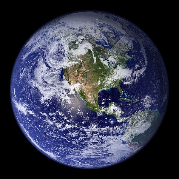
English: “Blue Marble”. Original caption:
Much of the information contained in this image came from a single remote-sensing device-NASA’s Moderate Resolution Imaging Spectroradiometer, or MODIS. Flying over 700 km above the Earth onboard the Terra satellite, MODIS provides an integrated tool for observing a variety of terrestrial, oceanic, and atmospheric features of the Earth. The land and coastal ocean portions of these images are based on surface observations collected from June through September 2001 and combined, or composited, every eight days to compensate for clouds that might block the sensor’s view of the surface on any single day. Two different types of ocean data were used in these images: shallow water true color data, and global ocean color (or chlorophyll) data. Topographic shading is based on the GTOPO 30 elevation dataset compiled by the U.S. Geological Survey’s EROS Data Center. MODIS observations of polar sea ice were combined with observations of Antarctica made by the National Oceanic and Atmospheric Administration’s AVHRR sensor—the Advanced Very High Resolution Radiometer. The cloud image is a composite of two days of imagery collected in visible light wavelengths and a third day of thermal infra-red imagery over the poles. Global city lights, derived from 9 months of observations from the Defense Meteorological Satellite Program, are superimposed on a darkened land surface map.
Data
Orixe http://visibleearth.nasa.gov/view.php?id=57723
Autoría
  • Reto Stöckli (land surface, shallow water, clouds)
  • Robert Simmon (enhancements: ocean color, compositing, 3D globes, animation)
  • Data and technical support: MODIS Land Group; MODIS Science Data Support Team; MODIS Atmosphere Group; MODIS Ocean Group
  • Additional data: USGS EROS Data Center (topography); USGS Terrestrial Remote Sensing Flagstaff Field Center (Antarctica); Defense Meteorological Satellite Program (city lights).
Outras versións Obras derivadas deste ficheiro:  Environment Barnstar new.png

Licenza

Public domain Este ficheiro está no dominio público porque foi creado pola NASA. A política do copyright da NASA declara que "o material da NASA non está protexido polos dereitos de autor a non ser que se indique o contrario". (Páxina de políticas do copyright da NASA ou política de uso de imaxes JPL).
Avisos:
  • O uso de logos da NASA, insignias e emblemas está restrinxido pola lei 14 CFR 1221 dos EE.UU.
  • A páxina web da NASA proporciona un gran número de imaxes dos soviéticos/ da axencia rusa do espazo e outras axencias espaciais non norteamericanas. Esta non están necesariamente no dominio público.
  • Os materiais do Telescopio Hubble poden ter copyright se non proveñen explicitamente do STScI. [1]
  • Todos os materiais creados polo SOHO teñen copyright e requiren dunha licenza para usos comerciais non educativos. [2]
  • As imaxes destacadas na páxina web do Día da imaxe astronómica (APOD) poden ter copyright. [3]

Pés de foto

Engada unha explicación dunha liña do representa este ficheiro

Elementos retratados neste ficheiro

representa a

Não existe nenhum valor para esta propriedade

Historial do ficheiro

Prema nunha data/hora para ver o ficheiro tal e como estaba nese momento.

Data/HoraMiniaturaDimensiónsUsuarioComentario
actual25 de agosto de 2005 ás 03:09Miniatura da versión ás 03:09 do 25 de agosto de 20052.048 × 2.048 (579 kB)Tom{{PD-USGov-NASA}} http://earthobservatory.nasa.gov/Newsroom/BlueMarble/Images/globe_west_2048.jpg Much of the information contained in this image came from a single remote-sensing device-NASA’s Moderate Resolution Imaging Spectroradiometer, or MODIS.

Non hai páxinas que usen este ficheiro.

Uso global do ficheiro

Os seguintes wikis empregan esta imaxe:

Ollar o uso global deste ficheiro.