Ficheiro:Caribbean Sea Gulf of Mexico shaded relief bathymetry land map.png
Ficheiro orixinal (1.024 × 664 píxeles; tamaño do ficheiro: 1,1 MB; tipo MIME: image/png)
| Este ficheiro procede de Wikimedia Commons. A continuación móstrase a información da súa páxina de descrición. Commons é un repositorio libre de ficheiros multimedia. Pode contribuír alí cargando as súas imaxes. |
Resumo
| Descrición |
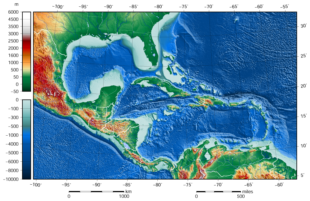
English: The shaded relief bathymetry and land map of the Caribbean Sea and Gulf of Mexico area. The map was created using the Generic Mapping Tools, GMT, version 5.1.1. |
| Data | |
| Orixe |
Obra própria, usando: the following Public Domain datasets for the relief:
Esta imaxe foi creada co GMT. |
| Autoría | Darekk2 using the ETOPO1 and GLOBE tiles |
| Outras versións |
The same image but contoured at -100 m: |

Licenza
Attribution (in addition to the author of this map):
The NGDC in it's copyright notice says:
As required by 17 U.S.C. 403, third parties producing copyrighted works consisting predominantly of the material produced by U.S. government agencies must provide notice with such work(s) identifying the U.S. Government material incorporated and stating that such material is not subject to copyright protection within the United States. (...)
(for credits see the Source section).
and GLOBE and ETOPO1
(see above and the Source section)
- Vostede é libre de:
- compartir – copiar, distribuír e difundir a obra
- facer obras derivadas – adaptar a obra
- Baixo as seguintes condicións:
- recoñecemento – Debe indicar a debida atribución de autoría, fornecer unha ligazón á licenza e indicar se se realizaron cambios. Pode facer isto de calquera forma razoable, mais non nunha forma que indique que quen posúe a licenza apoia ou subscribe o seu uso da obra.
- compartir igual – Se altera, transforma ou amplía este contido, debe publicar as súas contribucións baixo a mesma licenza ou outra compatible á orixinal.
Historial do ficheiro
Prema nunha data/hora para ver o ficheiro tal e como estaba nese momento.
| Data/Hora | Miniatura | Dimensións | Usuario | Comentario | |
|---|---|---|---|---|---|
| actual | 8 de xuño de 2015 ás 09:58 | | 1.024 × 664 (1,1 MB) | Darekk2 | added lakes ... and changed palette for land (white highest mountains) |
| 12 de maio de 2015 ás 15:23 |  | 1.024 × 664 (1,09 MB) | Darekk2 | changed the illumination azimuth from 100 to 45 deg. | |
| 21 de marzo de 2015 ás 15:59 |  | 1.024 × 664 (1,11 MB) | Darekk2 | a little wider in the east | |
| 21 de marzo de 2015 ás 15:07 |  | 1.024 × 664 (1,11 MB) | Darekk2 | changed parallels of the projection, removed black borderline | |
| 19 de marzo de 2015 ás 15:05 |  | 1.024 × 684 (1,15 MB) | Darekk2 | shortened elevation and depth legends | |
| 18 de marzo de 2015 ás 18:25 |  | 1.024 × 684 (1,15 MB) | Darekk2 | User created page with UploadWizard |
Uso do ficheiro
A seguinte páxina usa este ficheiro:
Uso global do ficheiro
Os seguintes wikis empregan esta imaxe:
- Uso en ar.wikipedia.org
- Uso en avk.wikipedia.org
- Uso en en.wikipedia.org
- Uso en hr.wikipedia.org
- Uso en sd.wikipedia.org
- Uso en sr.wikipedia.org
- Uso en vep.wikipedia.org