Ficheiro:Cape Town 2001 dominant language map.svg

Tamaño desta vista previa en PNG do ficheiro en formato SVG: 505 × 599 píxeles. Outras resolucións: 202 × 240 píxeles | 404 × 480 píxeles | 647 × 768 píxeles | 863 × 1.024 píxeles | 1.726 × 2.048 píxeles | 814 × 966 píxeles.
Ficheiro orixinal (ficheiro SVG; resolución de 814 × 966 píxeles; tamaño do ficheiro: 1,48 MB)
| Este ficheiro procede de Wikimedia Commons. A continuación móstrase a información da súa páxina de descrición. Commons é un repositorio libre de ficheiros multimedia. Pode contribuír alí cargando as súas imaxes. |
Resumo
| Descrición |
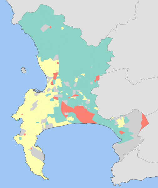
English: Map showing the dominant home languages in the City of Cape Town, Western Cape, South Africa, according to Census 2001 at the "Subplace" level. In this context, a language is dominant if it more than 50% of the population in an area speak it at home, or more than 33% speak it and no other language is spoken by more than 25%.
Afrikaans
English
isiXhosa
No language dominant |
| Data | |
| Orixe | Statistics South Africa's Census 2001 is the source of the basic population data. The map results from my own processing of the data. |
| Autoría | Htonl |
Licenza
The following license applies to the population data on which the map is based:

|
O propietario dos dereitos de autor deste ficheiro, Stats SA, permite que calquera poida usalo para calquera propósito, sempre e cando se lle recoñeza a autoría a quen cede os dereitos. A redistribución, edición, uso comercial e calquera outro tipo de uso están permitidos. |
Recoñecemento:
"the user acknowledges Stats SA as the source of the basic data wherever they process, apply, utilise, publish or distribute the data, and also that they specify that the relevant application and analysis (where applicable) result from their own processing of the data" [1]
|
The following tag applies to the map itself:
| Eu, como posuidor dos dereitos de autor desta obra, libéroa para que pertenza ao dominio público. Isto é válido en todo o mundo. Nalgúns países, isto pode non ser legalmente posible; entón: Concedo a calquera o dereito de empregar esta obra para o propósito que considere oportuno, sen condicións, agás aquelas que sexan requiridas pola lei. |
Historial do ficheiro
Prema nunha data/hora para ver o ficheiro tal e como estaba nese momento.
| Data/Hora | Miniatura | Dimensións | Usuario | Comentario | |
|---|---|---|---|---|---|
| actual | 16 de febreiro de 2010 ás 17:42 | | 814 × 966 (1,48 MB) | Htonl | size |
| 15 de febreiro de 2010 ás 21:17 |  | 842 × 1.000 (1,46 MB) | Htonl | tweak | |
| 15 de febreiro de 2010 ás 16:17 |  | 842 × 1.000 (1,37 MB) | Htonl | =={{int:filedesc}}== {{Information |Description={{en|1=Map showing the dominant home languages in the City of Cape Town, Western Cape, South Africa, according to Census 2001 at the "Subplace" level. In this context, a language is dominant if it more than |
Uso do ficheiro
A seguinte páxina usa este ficheiro:
Uso global do ficheiro
Os seguintes wikis empregan esta imaxe:
- Uso en be-tarask.wikipedia.org
- Uso en cy.wikipedia.org