Ficheiro:Britannica Figure of the Earth.jpg
Ficheiro orixinal (525 × 907 píxeles; tamaño do ficheiro: 84 kB; tipo MIME: image/jpeg)
| Este ficheiro procede de Wikimedia Commons. A continuación móstrase a información da súa páxina de descrición. Commons é un repositorio libre de ficheiros multimedia. Pode contribuír alí cargando as súas imaxes. |
Resumo
| Descrición |
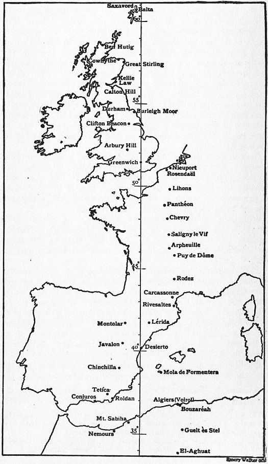
English: A meridian arc extending from the Shetland Islands, through Great Britain, France and Spain to El Aghuat in Algeria, whose parameters were calculated from surveys carried out in the mid to late 19th century. It yielded a value for the equatorial radius of the earth a = 6 377 935 metres, the ellipticity being assumed as 1/299.15. The radius of curvature of this arc is not uniform, being, in the mean, about 600 metres greater in the northern than in the southern part. The Greenwich meridian is depicted rather than the Paris meridian. |
| Data | |
| Orixe | Encyclopædia Britannica, 1911 |
| Autoría | Encyclopædia Britannica, Volume 8, Slice 9., available freely at Project Gutenberg |
Licenza
| This image comes from the 13th edition of the Encyclopædia Britannica or earlier. The copyrights for that book have expired in the United States because the book was first published in the US with the publication occurring before January 1, 1929. As such, this image is in the public domain in the United States. |  |
| This image comes from the Project Gutenberg archives. This is an image that has come from a book or document for which the American copyright has expired and this image is in the public domain in the United States and possibly other countries.
This eBook is for the use of anyone anywhere at no cost and with almost no restrictions whatsoever. You may copy it, give it away or re-use it under the terms of the Project Gutenberg License included with this eBook or online at www.gutenberg.net. |
Historial do ficheiro
Prema nunha data/hora para ver o ficheiro tal e como estaba nese momento.
| Data/Hora | Miniatura | Dimensións | Usuario | Comentario | |
|---|---|---|---|---|---|
| actual | 19 de febreiro de 2011 ás 16:46 | | 525 × 907 (84 kB) | Keith Edkins | =={{int:filedesc}}== {{Information |Description={{en|A meridian arc extending from the Shetland Islands, through Great Britain, France and Spain to El Aghuat in Algeria, whose parameters were calculated from surveys carried out in the mid to late 19th cen |
Uso do ficheiro
A seguinte páxina usa este ficheiro:
Uso global do ficheiro
Os seguintes wikis empregan esta imaxe:
- Uso en ar.wikipedia.org
- Uso en en.wikipedia.org
- Uso en en.wikisource.org
- Uso en es.wikipedia.org
- Uso en fr.wikipedia.org
- Uso en ru.wikipedia.org
- Uso en sl.wikipedia.org
- Uso en uk.wikipedia.org