Ficheiro:Bonobo distribution.svg

Tamaño desta vista previa en PNG do ficheiro en formato SVG: 635 × 600 píxeles. Outras resolucións: 254 × 240 píxeles | 508 × 480 píxeles | 813 × 768 píxeles | 1.084 × 1.024 píxeles | 2.169 × 2.048 píxeles | 1.525 × 1.440 píxeles.
Ficheiro orixinal (ficheiro SVG; resolución de 1.525 × 1.440 píxeles; tamaño do ficheiro: 577 kB)
| Este ficheiro procede de Wikimedia Commons. A continuación móstrase a información da súa páxina de descrición. Commons é un repositorio libre de ficheiros multimedia. Pode contribuír alí cargando as súas imaxes. |
Resumo
| Descrición |
Map: Lambert azimutal equal-area projection, WGS84 datum, standard meridian: 15°E, standard parallel: 0° Scale: 1:15,000,000 |
| Data | (UTC) |
| Orixe | |
| Autoría |
|
Licenza
Este ficheiro está licenciado baixo a licenza Creative Commons recoñecemento compartir igual 3.0 sen adaptar.
- Vostede é libre de:
- compartir – copiar, distribuír e difundir a obra
- facer obras derivadas – adaptar a obra
- Baixo as seguintes condicións:
- recoñecemento – Debe indicar a debida atribución de autoría, fornecer unha ligazón á licenza e indicar se se realizaron cambios. Pode facer isto de calquera forma razoable, mais non nunha forma que indique que quen posúe a licenza apoia ou subscribe o seu uso da obra.
- compartir igual – Se altera, transforma ou amplía este contido, debe publicar as súas contribucións baixo a mesma licenza ou outra compatible á orixinal.
Rexistro de cargas orixinal
This image is a derivative work of the following images:
- File:Africa_map_blank.svg licensed with Cc-by-sa-2.5,2.0,1.0, Cc-by-sa-3.0-migrated, GFDL
- 2011-07-14T19:50:24Z Sting 1525x1440 (698781 Bytes) Sudan/South Sudan 2011-07 border update
- 2009-01-10T20:36:44Z Sting 1525x1440 (710059 Bytes) Detail correction
- 2008-06-27T03:34:58Z Sting 1525x1440 (711453 Bytes) Completely new drawing with known projection
- 2006-05-31T15:28:42Z Sting 1390x1295 (571519 Bytes) Enhanced version : African and Asian continents separated
- 2006-05-31T03:53:32Z Sting 1390x1295 (566642 Bytes) {{Information |Description=Blank vector graphic map of [[:Category:Maps of Africa|Africa]] |Source=Several bitmap-type maps |Date= May 2006 |Author= Eric Gaba ([[User:Sting|Sting]]) |Permission=GFDL or CC-BY-SA |other_version
Carregada com derivativeFX
Historial do ficheiro
Prema nunha data/hora para ver o ficheiro tal e como estaba nese momento.
| Data/Hora | Miniatura | Dimensións | Usuario | Comentario | |
|---|---|---|---|---|---|
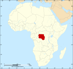
| actual | 18 de outubro de 2011 ás 08:51 | | 1.525 × 1.440 (577 kB) | Alphathon | == {{int:filedesc}} == {{Information |Description={{en|Map of the geographic distribution of bonobo's (''Pan paniscus'') within the African continent.}} Map: Lambert azimutal equal-area projection, WGS84 datum, |
Uso do ficheiro
A seguinte páxina usa este ficheiro:
Uso global do ficheiro
Os seguintes wikis empregan esta imaxe:
- Uso en af.wikipedia.org
- Uso en an.wikipedia.org
- Uso en ar.wikipedia.org
- Uso en arz.wikipedia.org
- Uso en avk.wikipedia.org
- Uso en azb.wikipedia.org
- Uso en bg.wikipedia.org
- Uso en bs.wikipedia.org
- Uso en ca.wikipedia.org
- Uso en cs.wikipedia.org
- Uso en da.wikipedia.org
- Uso en diq.wikipedia.org
- Uso en en.wikipedia.org
- Uso en en.wikiquote.org
- Uso en et.wikipedia.org
- Uso en eu.wikipedia.org
- Uso en ga.wikipedia.org
- Uso en he.wikipedia.org
- Uso en hi.wikipedia.org
- Uso en is.wikipedia.org
- Uso en it.wikipedia.org
- Uso en ka.wikipedia.org
- Uso en ku.wikipedia.org
- Uso en lt.wikipedia.org
- Uso en lv.wikipedia.org
- Uso en nn.wikipedia.org
- Uso en no.wikipedia.org
- Uso en os.wikipedia.org
- Uso en pa.wikipedia.org
- Uso en pl.wikipedia.org
- Uso en pnb.wikipedia.org
- Uso en pt.wikipedia.org
- Uso en ro.wikipedia.org
- Uso en ru.wikipedia.org
- Uso en sco.wikipedia.org
- Uso en simple.wikipedia.org
- Uso en sr.wikipedia.org
- Uso en tl.wikipedia.org
- Uso en tl.wikiquote.org
- Uso en tr.wikipedia.org
- Uso en uk.wikipedia.org
- Uso en vi.wikipedia.org
- Uso en www.wikidata.org