Ficheiro:Bermuda wv.jpg
Non se pode ver nunha resolución meirande.
Bermuda_wv.jpg (800 × 600 píxeles; tamaño do ficheiro: 335 kB; tipo MIME: image/jpeg)
| Este ficheiro procede de Wikimedia Commons. A continuación móstrase a información da súa páxina de descrición. Commons é un repositorio libre de ficheiros multimedia. Pode contribuír alí cargando as súas imaxes. |
Resumo
| Descrición |
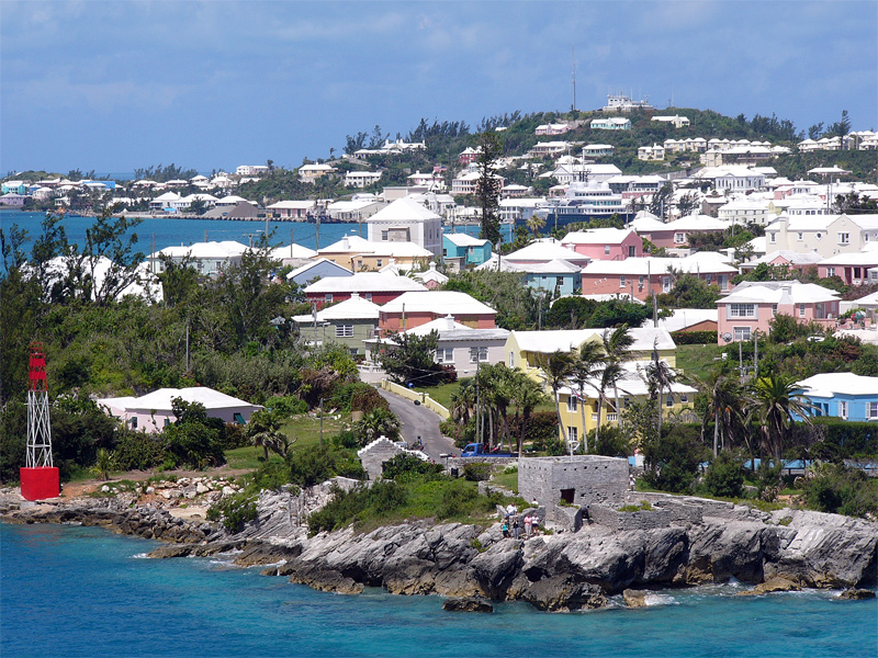
English: Residential suburb near the old St. George's Garrison, with "Town Cut Battery" or "Gate's Fort" in the foreground (with Cut Road behind it), on the northern side of the Town Cut shipping channel, and St. George's Town and harbour in the background, with Fort George on the peak of Mount Hill beyond, and a small ship is visible docked at Ordnance Island, off the town square]].
The Town Cut had been a minor channel, suitable only for small vessels to enter or exit the harbour, until dredged before the First World War. Before then, larger vessels had used the St. George's Channel between Paget Island and Governor's Island, which was watched over by Fort Paget (on Paget Island) and Smith's Fort (on Governor's Island). In the 19th Century, Fort Cunningham was erected on Paget Island, making all three of the earlier batteries redundant. Alexandra Battery (at Building Bay on St. George's Island, immediately to the north of Cut Battery) and St. David's Battery on St. David's Island were later added (there were also three other forts armed with coastal artillery batteries to the North-West of Building Bay: Fort St. Catherine's at St. Catherine's Point, and Fort Victoria and Fort Albert on Retreat Hill, to its rear). St. George's Town and the various forts and related military installations at the East End of Bermuda are together a United Nations Educational, Scientific and Cultural Organization's (UNESCO) World Heritage Site, the Historic Town of St George and Related Fortifications, Bermuda.[1][2] |
| Data | 24 de agosto de 2006 (data de subida orixinal) |
| Orixe | Obra propia |
| Autoría | (WT-en) Legrospaumé em Wikivoyage em inglés |
| Localización da cámara | | Esta e outras imaxes na súa localización en: OpenStreetMap |
|---|
References
- ↑ Bermuda Forts 1612–1957, Dr. Edward C. Harris, The Bermuda Maritime Museum Press, The Bermuda Maritime Museum, P.O. Box MA 133, Mangrove Bay, Bermuda MA BX, ISBN 0-921560-11-7
- ↑ UNESCO World Heritage Centre: Historic Town of St George and Related Fortifications, Bermuda
Licenza
| O autor desta obra, (WT-en) Legrospaumé em Wikivoyage em inglés, liberouna e agora pertence ao dominio público. Isto é válido en todo o mundo. Nalgúns países, isto pode non ser legalmente posible; entón: (WT-en) Legrospaumé em Wikivoyage em inglés concede a calquera o dereito de empregar esta obra para o propósito que considere oportuno, sen condicións, agás aquelas que sexan requiridas pola lei.
|
Rexistro de cargas orixinal
| This file was imported from Wikivoyage en. |
A páxina orixinal de descrición está aquí. Tódolos seguintes nomes de usuario refírense a en.wikivoyage-old.
- 2006-08-24 12:07 (WT-en) Legrospaumé 800×600 (343391 bytes) Bermuda (Import from wikitravel.org/en)
Historial do ficheiro
Prema nunha data/hora para ver o ficheiro tal e como estaba nese momento.
| Data/Hora | Miniatura | Dimensións | Usuario | Comentario | |
|---|---|---|---|---|---|
| actual | 8 de xaneiro de 2013 ás 19:09 | | 800 × 600 (335 kB) | MGA73bot2 | {{BotMoveToCommons|en.oldwikivoyage|year={{subst:CURRENTYEAR}}|month={{subst:CURRENTMONTHNAME}}|day={{subst:CURRENTDAY}}}} == {{int:filedesc}} == {{Information |description=Bermuda |date={{Date|2006|8|24}} (original upload date) |source={{Own}}<BR />{{... |
Uso do ficheiro
A seguinte páxina usa este ficheiro:
Uso global do ficheiro
Os seguintes wikis empregan esta imaxe:
- Uso en el.wikipedia.org
- Uso en en.wikipedia.org
- Uso en en.wikivoyage.org
- Uso en es.wikivoyage.org
- Uso en fi.wikipedia.org
- Uso en id.wikipedia.org
- Uso en ja.wikipedia.org
- Uso en mt.wikipedia.org
- Uso en nl.wikipedia.org
- Uso en pt.wikipedia.org
- Uso en simple.wikipedia.org
- Uso en vi.wikipedia.org
- Uso en vi.wikivoyage.org