Ficheiro:1750 Homann Heirs Map of Israel - Palestine - Holy Land (12 Tribes) - Geographicus - Palestina-homannheirs-1750.jpg
Tamaño desta vista previa: 662 × 599 píxeles. Outras resolucións: 265 × 240 píxeles | 530 × 480 píxeles | 848 × 768 píxeles | 1.131 × 1.024 píxeles | 2.262 × 2.048 píxeles | 4.000 × 3.622 píxeles.
Ficheiro orixinal (4.000 × 3.622 píxeles; tamaño do ficheiro: 3,02 MB; tipo MIME: image/jpeg)
| Este ficheiro procede de Wikimedia Commons. A continuación móstrase a información da súa páxina de descrición. Commons é un repositorio libre de ficheiros multimedia. Pode contribuír alí cargando as súas imaxes. |
_-_Geographicus_-_Palestina-homannheirs-1750.jpg)
| Palaestina in XII Tribus divisa cum Terris Adiacentibus… | ||||||
|---|---|---|---|---|---|---|
| Artista | ||||||
| Título |
Palaestina in XII Tribus divisa cum Terris Adiacentibus… |
|||||
| Descrición |
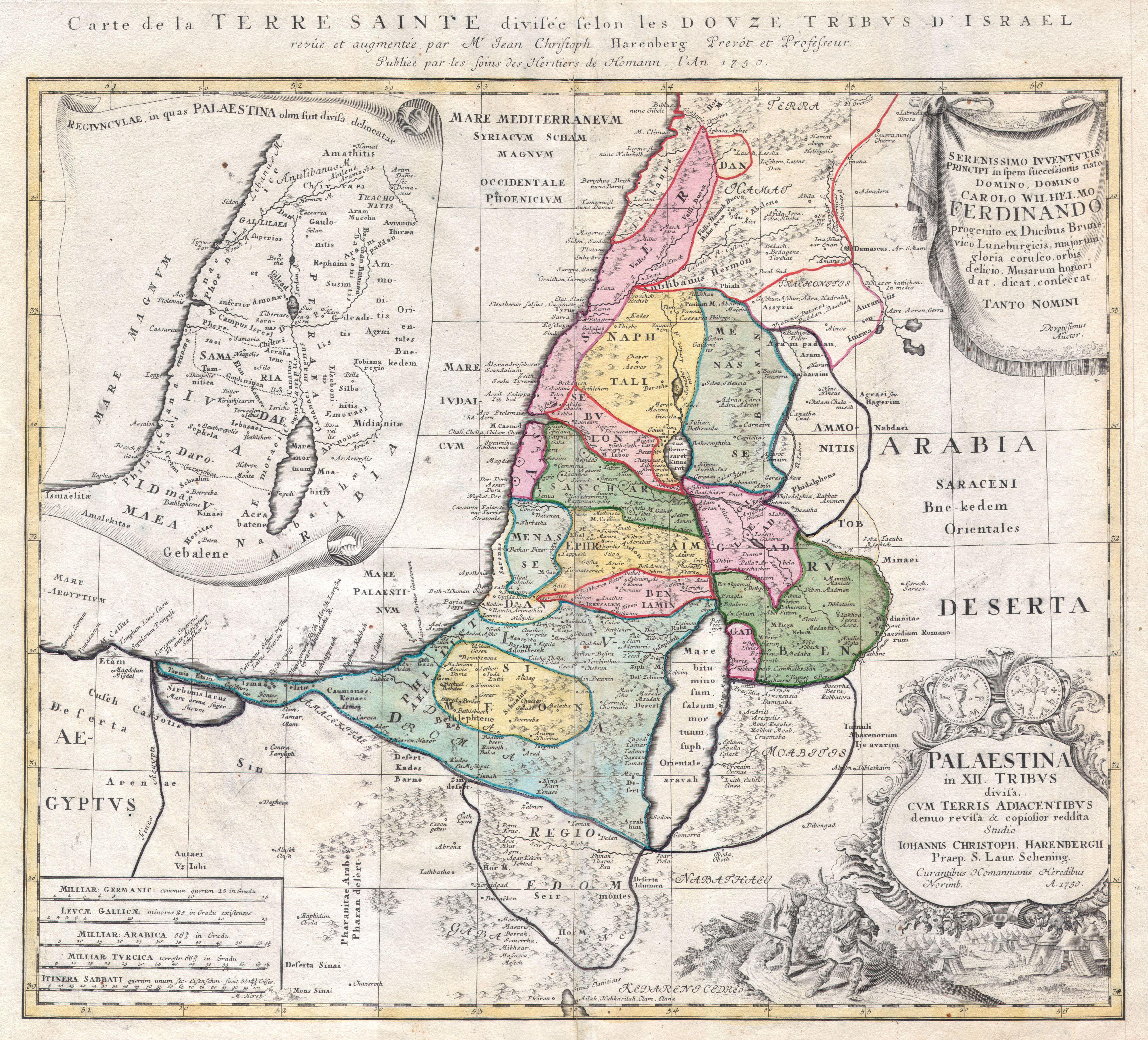
English: This is one of the Homann Heirs finest and most appealing maps of Palestine / Israel / The Holy Land. Depicts the region divided into the 12 Tribes of Israel. In the right hand corners there are two title cartouches. The lower is exceptionally decorative and depicts with two spies of Moses bearing the fruit from the Promised Land to the Hebrew camp, as well as the front and back of an ancient shekel coin. The upper left quadrant offers an overview of the region as a whole. The upper right features a dedication from the mapmaker to Karl Wilhelm Ferdinand, the future Duke of Braunschweig-Wolfenbüttel and Braunschweig-Lüneburg (from 1773). This map was drawn by Johann Christoph Harenberg.for inclusion the 1752 Homann Heirs Maior Atlas Scholasticus ex Triginta Sex Generalibus et Specialibus…. Most early Homann atlases were “made to order” or compiled of individual maps at the request of the buyer. However, this rare atlas, composed of 37 maps and charts, was issued as a “suggested collection” of essential Homann Heirs maps. A fine copy of an important map. |
|||||
| Data | 1750 | |||||
| Dimensións | altura: 19 pulgadas (48,2 cm); ancho: 21 pulgadas (53,3 cm) | |||||
| Número de acceso |
Geographicus link: Palestina-homannheirs-1750 |
|||||
| Orixe/Fotógrafo |
|
|||||
| Licenza (Reuso deste ficheiro) |
|
|||||
Historial do ficheiro
Prema nunha data/hora para ver o ficheiro tal e como estaba nese momento.
| Data/Hora | Miniatura | Dimensións | Usuario | Comentario | |
|---|---|---|---|---|---|
| actual | 24 de marzo de 2011 ás 12:06 | | 4.000 × 3.622 (3,02 MB) | BotMultichillT | {{subst:User:Multichill/Geographicus |link=http://www.geographicus.com/P/AntiqueMap/Palestina-homannheirs-1750 |product_name=1750 Homann Heirs Map of Israel / Palestine / Holy Land (12 Tribes) |map_title=Palaestina in XII Tribus divisa cum Terris Adiacent |
Uso do ficheiro
A seguinte páxina usa este ficheiro:
Uso global do ficheiro
Os seguintes wikis empregan esta imaxe:
- Uso en es.wikipedia.org
_-_Geographicus_-_Palestina-homannheirs-1750.jpg)