Ficheiro:Polish and Lithuanian Conflict with Prussia. 1377-1435..png
Tamaño desta vista previa: 696 × 600 píxeles. Outras resolucións: 279 × 240 píxeles | 557 × 480 píxeles | 968 × 834 píxeles.
Ficheiro orixinal (968 × 834 píxeles; tamaño do ficheiro: 182 kB; tipo MIME: image/png)
| Este ficheiro procede de Wikimedia Commons. A continuación móstrase a información da súa páxina de descrición. Commons é un repositorio libre de ficheiros multimedia. Pode contribuír alí cargando as súas imaxes. |
Resumo
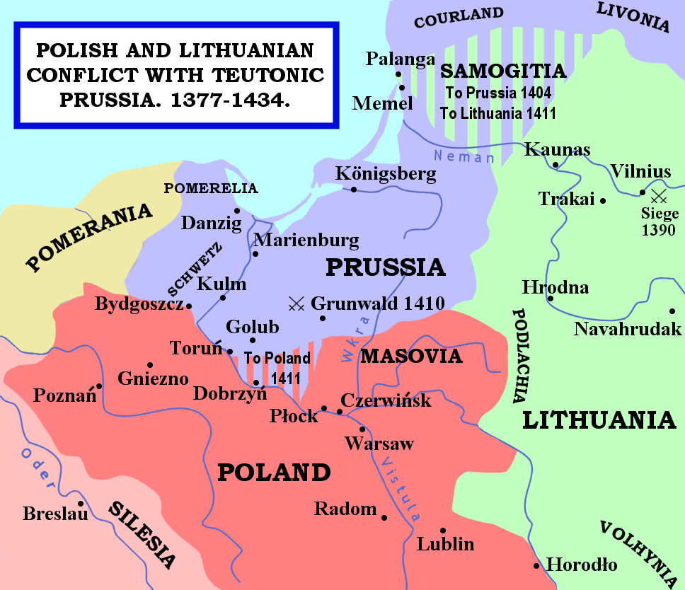
| Descrición | The map shows the areas of conflict between Teutonic Prussia and Poland and Lithuania during the reigns of Jogaila (Władysław II Jagiełło) and Vytautas. The areas on the borders of Prussia and Poland were particularly disputed: towns often changed hands, and Dobrzyń Land (red-and-mauve stripes) was passed back and forward as a result of various deals, treaties, and battles. Samogitia (green-and-mauve stripes) was also strongly disputed between the Teutonic Order and Lithuania, because the Knights wished to link up with the Livonian Lands further north. After the Battle of Grunwald in 1410, a series of treaties established Polish control over Dobrzyń Land and Lithuanian control over Samogitia for good, marking the beginning of the Teutonic State's decline. |
| Data | 29 de xaneiro de 2007 (data de subida orixinal) |
| Orixe | No machine-readable source provided. Own work assumed (based on copyright claims). |
| Autoría | No machine-readable author provided. Qp10qp assumed (based on copyright claims). |
Sources
- The map was outlined from this old German map: Image:Poland under Jagello.jpg.
Other references:
- The Times Concise Atlas of World History, Times Books, 1994, ISBN 0-7230-0674-1, p. 56.
- Lukowski, Jerzy and Hubert Zawadzki (2001). A Concise History of Poland. Cambridge: Cambridge University Press. ISBN 0-521-55917-0. Maps on p. 36-38.
- "Baltic Europe", in The New Cambridge Medieval History VI, ed. Michael Jones, Cambridge University Press, ISBN 0-521-36290-3. Map on p. 700.
Licenza
| Eu, como posuidor dos dereitos de autor desta obra, libéroa para que pertenza ao dominio público. Isto é válido en todo o mundo. Nalgúns países, isto pode non ser legalmente posible; entón: Concedo a calquera o dereito de empregar esta obra para o propósito que considere oportuno, sen condicións, agás aquelas que sexan requiridas pola lei. |
Historial do ficheiro
Prema nunha data/hora para ver o ficheiro tal e como estaba nese momento.
| Data/Hora | Miniatura | Dimensións | Usuario | Comentario | |
|---|---|---|---|---|---|
| actual | 14 de febreiro de 2007 ás 23:22 | | 968 × 834 (182 kB) | Qp10qp | |
| 29 de xaneiro de 2007 ás 07:05 |  | 968 × 834 (182 kB) | Qp10qp | The map shows the areas of conflict between Teutonic Prussia and Poland and Lithuania during the reigns of Jogaila (Władysław II Jagiełło) and Vytautas. The areas on the borders of Prussia and Poland were particularly disputed: towns changed often cha |
Uso do ficheiro
A seguinte páxina usa este ficheiro:
Uso global do ficheiro
Os seguintes wikis empregan esta imaxe:
- Uso en ar.wikipedia.org
- Uso en ast.wikipedia.org
- Uso en az.wikipedia.org
- Uso en da.wikipedia.org
- Uso en en.wikipedia.org
- Uso en es.wikipedia.org
- Uso en fr.wikipedia.org
- Uso en he.wikipedia.org
- Uso en hu.wikipedia.org
- Uso en id.wikipedia.org
- Uso en it.wikipedia.org
- Uso en ja.wikipedia.org
- Uso en lt.wikibooks.org
- Uso en pl.wikipedia.org
- Uso en pt.wikipedia.org
- Uso en sl.wikipedia.org
- Uso en tr.wikipedia.org
- Uso en uk.wikipedia.org
- Uso en vls.wikipedia.org
- Uso en www.wikidata.org
- Uso en zh.wikipedia.org