Ficheiro:Negroland and Guinea with the European Settlements, 1736.jpg

Ficheiro orixinal (1.200 × 894 píxeles; tamaño do ficheiro: 1,55 MB; tipo MIME: image/jpeg)
| Este ficheiro procede de Wikimedia Commons. A continuación móstrase a información da súa páxina de descrición. Commons é un repositorio libre de ficheiros multimedia. Pode contribuír alí cargando as súas imaxes. |
Map|thumb|alt=https://www.canva.com/design/DAEqyLnPwRY/share/preview?token=KSHUFcVdAgta6UUstYCF7w&role=EDITOR&utm_content=DAEqyLnPwRY&utm_campaign=designshare&utm_medium=link&utm_source=sharebutton%7CThis 1747 Map reflects the various Kingdoms. The Kingdom of Juda(h). Ouidah /ˈwiːdə/, also Whydah /ˈhwaɪdə/ ]]
Resumo
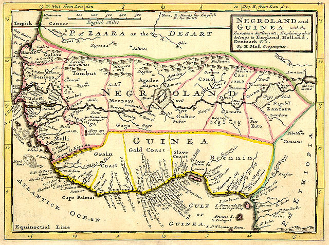
| Descrición | Full title: 'Negroland and Guinea with the European Settlements, Explaining what belongs to England, Holland, Denmark, etc'. By H. Moll Geographer (Printed and sold by T. Bowles next ye Chapter House in St. Pauls Church yard, & I. Bowles at ye Black Horse in Cornhill, 1729, orig. published in 1727). [1] |
| Data | |
| Orixe | University of Florida, George A. Smathers Libraries, historic African maps: 1729 Herman Moll (#ALW1663) |
| Autoría | Herman Moll |
Licenza
|
Este material está no dominio público nos demais países onde os dereitos de autor se estenden por 100 anos (ou menos) trala morte do autor. | |
| Este ficheiro foi identificado como libre de restricións baixo as leis de dereitos de autor, incluídos todos os dereitos relacionados. | |
Rexistro de cargas orixinal
(All user names refer to en.wikipedia)
- 2006-06-13 23:18 LIL T 1200×894×8 (1624023 bytes)
Historial do ficheiro
Prema nunha data/hora para ver o ficheiro tal e como estaba nese momento.
| Data/Hora | Miniatura | Dimensións | Usuario | Comentario | |
|---|---|---|---|---|---|
| actual | 3 de febreiro de 2008 ás 06:16 | | 1.200 × 894 (1,55 MB) | BetacommandBot | move approved by: User:Dcoetzee This image was moved from Image:ALW1663L.jpg {{Information |Description=Full title: 'Negroland and Guinea with the European Settlements, Explaining what belongs to England, Holland, Denmark, etc'. By [[:en:Herman |
Uso do ficheiro
A seguinte páxina usa este ficheiro:
Uso global do ficheiro
Os seguintes wikis empregan esta imaxe:
- Uso en an.wikipedia.org
- Uso en ar.wikipedia.org
- Uso en ba.wikipedia.org
- Uso en be.wikipedia.org
- Uso en bn.wikipedia.org
- Uso en br.wikipedia.org
- Uso en bs.wikipedia.org
- Uso en ca.wikipedia.org
- Uso en ceb.wikipedia.org
- Uso en cs.wikipedia.org
- Uso en cv.wikipedia.org
- Uso en da.wikipedia.org
- Uso en de.wikipedia.org
- Uso en en.wikipedia.org
- Uso en eo.wikipedia.org
- Uso en es.wikipedia.org
- Uso en eu.wikipedia.org
- Uso en fa.wikipedia.org
- Uso en fi.wikipedia.org
- Uso en fr.wikipedia.org
Ollar o uso global deste ficheiro.