Ficheiro:Location Ryukyu Islands.PNG

Tamaño desta vista previa: 550 × 599 píxeles. Outras resolucións: 220 × 240 píxeles | 441 × 480 píxeles | 906 × 987 píxeles.
Ficheiro orixinal (906 × 987 píxeles; tamaño do ficheiro: 151 kB; tipo MIME: image/png)
| Este ficheiro procede de Wikimedia Commons. A continuación móstrase a información da súa páxina de descrición. Commons é un repositorio libre de ficheiros multimedia. Pode contribuír alí cargando as súas imaxes. |
Resumo
| Descrición |
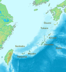
English: Location map of the Ryukyu islands (Nansei islands). According to the standardized geographical names of Japan, the Nansei Islands (南西諸島, Nansei Shotō, lit. "Southwest Islands") cover the entire island chain: the Ōsumi, Tokara, Amami, Okinawa, Sakishima Islands (further divided into the Miyako and Yaeyama Islands), the Senkaku Islands, and the Daitō Islands, with Yonaguni the westernmost. |
| Data | 2006, 2022 |
| Orixe | Obra propia |
| Autoría | Nanshu, Michiel1972 |
| Outras versións | alternative version: File:Location of the Ryukyu Islands.JPG |
Licenza
This image is in the public domain because it came from the site https://www.demis.nl/products/web-map-server/examples/ and was released by the copyright holder. Permission is granted to copy, distribute and/or modify this map since it is based on free of copyright images from: www.demis.nl. See also approval email on de.wp and its clarification.
|
| Esta obra foi colocada em domínio público pelo detentor dos direitos autorais, www.demis.nl. Isto se aplica em todo o mundo. Nalgúns países, isto pode non ser legalmente posible; entón: www.demis.nl concede a calquera o dereito de empregar esta obra para o propósito que considere oportuno, sen condicións, agás aquelas que sexan requiridas pola lei.
|
Historial do ficheiro
Prema nunha data/hora para ver o ficheiro tal e como estaba nese momento.
| Data/Hora | Miniatura | Dimensións | Usuario | Comentario | |
|---|---|---|---|---|---|
| actual | 21 de maio de 2022 ás 07:53 | | 906 × 987 (151 kB) | A1Cafel | Reverted to version as of 08:43, 3 April 2022 (UTC) |
| 13 de maio de 2022 ás 07:26 |  | 2.309 × 1.594 (527 kB) | Sturmgewehr88 | Higher resolution map | |
| 3 de abril de 2022 ás 08:43 |  | 906 × 987 (151 kB) | Nanshu | Adjust locations. Larger labels. | |
| 19 de xaneiro de 2006 ás 22:45 |  | 482 × 377 (85 kB) | Michiel1972 | *Location_Ryukyu_Islands {{demis}} |
Uso do ficheiro
Non hai páxinas que usen este ficheiro.
Uso global do ficheiro
Os seguintes wikis empregan esta imaxe:
- Uso en ar.wikipedia.org
- Uso en en.wikipedia.org
- Uso en fr.wikipedia.org
- Uso en hak.wikipedia.org
- Uso en ro.wikipedia.org
- Uso en sn.wikipedia.org
- Uso en uk.wikipedia.org
- Uso en zh-min-nan.wikipedia.org
- Uso en zh-yue.wikipedia.org
- Uso en zh.wikipedia.org