Ficheiro:Carquinez Strait aerial view.jpg

Tamaño desta vista previa: 800 × 533 píxeles. Outras resolucións: 320 × 213 píxeles | 640 × 426 píxeles | 1.024 × 682 píxeles | 1.500 × 999 píxeles.
Ficheiro orixinal (1.500 × 999 píxeles; tamaño do ficheiro: 840 kB; tipo MIME: image/jpeg)
| Este ficheiro procede de Wikimedia Commons. A continuación móstrase a información da súa páxina de descrición. Commons é un repositorio libre de ficheiros multimedia. Pode contribuír alí cargando as súas imaxes. |
| Descrición |
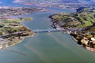
English: Aerial view of Carquinez Strait, which is the outflow of the Sacramento River into San Pablo Bay between Solano and Contra Costa Counties, California, USA. In the photograph, Solano County is on the left of the strait and Contra Costa County is on the right. The Carquinez Bridge, carrying Interstate 80, is visible in the foreground. The Benicia-Martinez Bridge is visible in the far distance. The communities of Crocket, Port Costa, and Martinez lie on the right side in Contra Costa County. The city of Vallejo lies off to the left, not visible in the picture. Benicia, California, is visible at top left. Through Carquinez Strait and Suisun Bay, the river is navigable by deep-water vessels.
Coordinates: 38°3′43.25″N 122°13′34.18″W / 38.0620139°N 122.2261611°W |
||
| Data | not specified or unknown | ||
| Orixe |
U.S. Army Corps of Engineers Digital Visual Library Image page Image description page Digital Visual Library home page |
||
| Autoría | Robert Campbell | ||
| Licenza (Reuso deste ficheiro) |
Este ficheiro está licenciado baixo a licenza Creative Commons recoñecemento compartir igual 3.0 sen adaptar.
|
||
| Localización | Solano and Contra Costa Counties, California, USA |

Historial do ficheiro
Prema nunha data/hora para ver o ficheiro tal e como estaba nese momento.
| Data/Hora | Miniatura | Dimensións | Usuario | Comentario | |
|---|---|---|---|---|---|
| actual | 4 de maio de 2007 ás 01:02 | | 1.500 × 999 (840 kB) | DanMS | {{Information | Description = {{en|Aerial view of Carquinez Strait, which is the outflow of the Sacramento River into San Pablo Bay between Solano and Contra Costa Counties, California, USA. In the photograph, Solano County is on the left of the strait |
Uso do ficheiro
A seguinte páxina usa este ficheiro:
Uso global do ficheiro
Os seguintes wikis empregan esta imaxe:
- Uso en ar.wikipedia.org
- Uso en ca.wikipedia.org
- Uso en ceb.wikipedia.org
- Uso en de.wikipedia.org
- Uso en en.wikipedia.org
- Uso en fa.wikipedia.org
- Uso en fr.wikipedia.org
- Uso en it.wikipedia.org
- Uso en ja.wikipedia.org
- Uso en ko.wikipedia.org
- Uso en nl.wikipedia.org
- Uso en pt.wikipedia.org
- Uso en www.wikidata.org